Unlocking the untapped potential of legacy seismic data using modern processing and imaging technology
DHVANIL PATEL, Viridien
In many asset teams, seismic volumes gradually shift from being decision-making tools to background references. Once interpreted and drilled against, older surveys are often archived, while attention moves toward new acquisition. However, in capital-intensive basins, treating seismic as static reference material can embed inherited modeling assumptions into drilling and development strategies that involve substantial capital exposure.
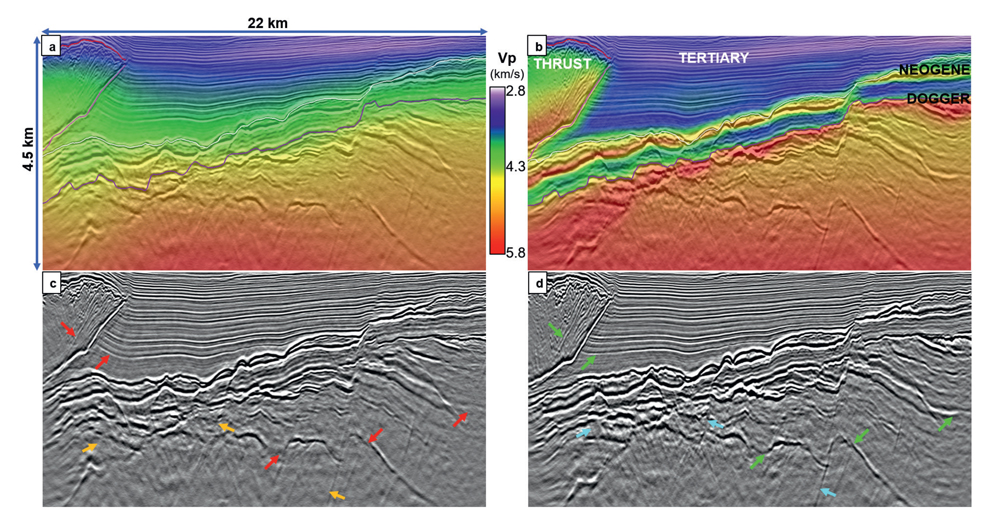
Over the past 15 years, seismic imaging technology has evolved in ways that justify a systematic reassessment of legacy datasets, Fig. 1. Advances in anisotropy modeling, multi-survey integration, wave-equation migration and full-waveform inversion (FWI) have expanded what can be extracted from existing wavefields. Structural positioning, velocity fidelity and depth consistency that were previously constrained by computational limits are now achievable at industrial scale. For established producing fields with significant capital exposure, reassessing the technical limits of existing seismic volumes may provide greater immediate value than defaulting to new acquisition.
VELOCITY AND ANISOTROPY MODELING CONSTRAINTS IN LEGACY WORKFLOWS
Reprocessing work in mature offshore developments consistently revealed that velocity and anisotropy assumptions embedded in earlier workflows were limiting image reliability far more than acquisition geometry. One offshore development project illustrates the issue clearly. There, the legacy velocity model had been constructed, using simplified one-dimensional anisotropy profiles, extrapolated from nearby areas without direct well calibration. On the resulting migrated volumes, gathers flattened satisfactorily and structural geometries appeared coherent, giving the impression that the depth model was reliable.
Only after drilling did systematic depth misties emerge—in some cases approaching hundreds of feet—revealing positional bias introduced by the inherited velocity framework. Flat gathers are necessary, but they are not sufficient; calibration and geological plausibility ultimately determine whether a velocity model is decision-ready.
The reflections themselves remained coherent, but the depth positioning exhibited systematic bias. Because the geometry looked reasonable on section, the depth bias remained difficult to isolate without well control. This type of misalignment is not uncommon in fields where imaging quality is judged primarily by gather flatness, rather than by geological plausibility.
Historically, workflows compensated by using iterative velocity updates and FWI layered on top of inherited anisotropy constraints. While kinematic convergence improved, the anisotropy framework itself often remained insufficiently constrained. Rebuilding anisotropy in three dimensions, guided by geological context and calibrated to wells, materially changed depth reliability. Once anisotropy parameters were re-established and updated through FWI, depth residuals narrowed by approximately 90%, relative to the legacy model, and well ties stabilized, indicating a velocity framework driven by calibration and physical constraints.
COMPUTATIONAL AND METHODOLOGICAL LIMITS IN EARLY PROCESSING CYCLES
Legacy surveys were typically processed within the computational constraints of their time. Earlier workflows relied on simplified velocity parameterization, Kirchhoff migration, narrower bandwidth assumptions and less adaptive multiple attenuation strategies. Model building iterations were limited by available computing resources, and high-frequency inversion was not practical at scale.
In structurally complex environments, even small velocity inaccuracies propagate directly into depth mispositioning. In thin or stratigraphically subtle reservoirs, signal-to-noise limitations obscure heterogeneity and reduce interpretive confidence. A modest velocity bias can translate into structural displacement sufficient to influence well placement or reserve estimation. Many mature assets continue to operate on volumes considered operationally adequate, though not necessarily geologically optimized.
TOMOGRAPHY, MULTI-SURVEY INTEGRATION, AND MODEL CONSISTENCY
Comparisons between independently processed surveys in the same basin often reveal subtle inconsistencies that remain hidden when datasets are evaluated in isolation. Each survey may achieve flat gathers through tomography, yet merging adjacent velocity models can expose discontinuities along flanks or beneath strong velocity contrasts. Gather flatness indicates internal consistency under assumed parameters; it does not confirm geological accuracy.
Integrating long-offset FWI within a unified multi-survey modeling framework often reveals incremental but consequential improvements. Illumination gaps reduce, velocity anomalies align more closely with well logs and structural positioning becomes consistent across survey boundaries. The emphasis shifts to model plausibility and cross-survey coherence, reducing dependence on isolated convergence metrics.
TECHNOLOGICAL EVOLUTION IN SEISMIC IMAGING WORKFLOWS
Although the theoretical foundations of modern techniques have existed for years, their deployment at scale has transformed imaging reliability. High-performance computing now supports industrial-scale FWI, broadband deghosting and multi-azimuth integration. Least-squares migration improves amplitude balancing and suppresses acquisition footprint, and wave-equation refinements enhance stability in structurally complex areas.
Elastic FWI has further addressed limitations observed in acoustic inversion, particularly in salt-flank environments where halo artifacts, velocity smoothing and manual correction cycles historically masked structural uncertainty. In certain basins, elastic implementations have demonstrated sharper flank definition and reduced interpretive adjustment during model building. These developments collectively represent a shift from image enhancement toward physics-driven validation of subsurface models.
MULTI-VINTAGE DATA AS A UNIFIED WAVEFIELD RESOURCE
Many basins contain overlapping datasets acquired over decades, including narrow-azimuth streamer surveys from earlier development phases, wide-azimuth acquisitions from subsequent campaigns and, in some areas, ocean-bottom node data collected to improve illumination beneath complex overburden. In most cases, each survey was processed as a standalone project, constrained by its specific acquisition geometry and evaluated within its own velocity framework.
The result is often a patchwork of internally consistent volumes that do not necessarily align with one another in depth or amplitude response. Reprocessing at technical limit reframes these datasets as components of a single, unified wavefield, allowing complementary offsets and azimuths to be leveraged in a coherent velocity and migration strategy, instead of being treated as isolated interpretations.
In our integration workflows, the greatest instability often emerges at survey boundaries where independently derived velocity models intersect. When overlapping surveys are evaluated within a unified modeling framework, complementary azimuths and offset ranges begin to address illumination gaps that were inherent to each individual acquisition. Long offsets that were underutilized in earlier processing cycles can stabilize inversion updates, while alternative azimuths provide more reliable imaging along fault planes and salt flanks where directional illumination is critical.
The cumulative effect is not dramatic in a single iteration; rather, incremental gains in multiple attenuation, velocity consistency and migration stability compound over successive updates. What emerges is a model that is more internally coherent across the field: the result of integrating the combined wavefield within a coordinated framework instead of processing each survey as an isolated dataset.
Comparable uplift has been observed in Gulf of Mexico reprocessing efforts, including a Mississippi Canyon case study presented at the International Meeting for Applied Geoscience & Energy, where joint demultiple, FWI and least-squares migration produced measurable reservoir-level improvements through disciplined cross-survey reconciliation.1
DEPTH UNCERTAINTY AND CAPITAL RISK
Depth uncertainty remains one of the most consequential risk drivers in structural plays, particularly in developments where trap integrity and well placement tolerances are narrow. Structural closures depend on precise depth positioning, and thin pay intervals leave limited margin for error in trajectory design. A velocity bias that appears modest in time can translate into tens of meters of structural displacement in depth, shifting spill points, altering fault juxtapositions, or subtly redefining compartment boundaries. In a drilling program with multiple planned wells, that displacement propagates directly into reserve estimates, trajectory adjustments and ultimately, capital efficiency.
Long-offset and wide-azimuth FWI workflows have materially improved the stability of velocity models in these environments, not by dramatically changing the image, but rather by tightening residual depth errors and improving consistency between wells. On section, the updates may look incremental. In practice, stabilized well ties, reduced depth conversion spread and clearer structural intersections provide a more defensible basis for development planning. The value lies less in visual sharpness and more in the reduction of structural ambiguity that influences capital deployment decisions.
PHYSICAL LIMITS OF REPROCESSING AND DECISION DISCIPLINE
Even with contemporary workflows, reprocessing remains bounded by the physics of acquisition. Illumination cannot be created where offsets were never recorded, and azimuth diversity cannot be reconstructed, if it was not captured in the field. Sparse acquisition geometries and a limited aperture impose constraints that no inversion algorithm can fully overcome. Recognizing those limits is part of disciplined evaluation.
Modern processing workflows clearly exceed the capabilities of legacy approaches; the more relevant evaluation is whether the resulting reduction in uncertainty meaningfully alters the timing or scope of new acquisition. In some developments, technical-limit reprocessing clarifies structural risk sufficiently to defer additional surveys. In others, it exposes illumination deficiencies that confirm the need for expanded acquisition. When properly framed, the exercise functions as a disciplined evaluation of methodological versus geological uncertainty, moving beyond cosmetic image enhancement.
LEGACY SEISMIC AS AN ACTIVE ENGINEERING ASSET
New acquisition unquestionably increases offset diversity and azimuth coverage, and in structurally complex basins, it may be indispensable. At the same time, legacy datasets often retain recoverable information that was constrained more by prior workflow assumptions than by acquisition quality. Reassessing inherited velocity frameworks, anisotropy models and migration strategies using contemporary tools frequently reveals inconsistencies that were previously masked by computational limitations.
Treating legacy seismic as an active engineering asset reframes it from archival reference to decision infrastructure. Improvements in velocity modeling, cross-survey alignment and well calibration may appear incremental on section, but they reduce structural ambiguity where it matters most: at the point of capital commitment. In high-exposure drilling programs, disciplined refinement of the existing wavefield can deliver risk reduction that rivals the value of new acquisition, because clarity in depth positioning ultimately governs how confidently capital is deployed.

DHVANIL PATEL is an Imaging Project coordinator at Viridien (formerly CGG) in Houston, Texas, where he leads and supports 3D seismic data processing projects across offshore and onshore basins. His work focuses on depth imaging, multi-survey integration and the application of advanced technologies, such as reverse time migration (RTM), wave-equation migration and full-waveform inversion, to improve subsurface model fidelity. Mr. Patel holds a master’s degree in petroleum engineering from Texas A&M University and has contributed to published technical research in seismic reprocessing and subsurface modeling. His experience spans high-performance computing environments, velocity model building and collaboration with asset teams to align imaging workflows with asset requirements and deliver optimized geological outcomes.
REFERENCES
Related Articles- Building a smarter model for sustainable land seismic operations (May)
- What's new in exploration: Financial distractions, investor rationalizations, exploration laments (May)
- Opening new frontiers in formation evaluation: Transforming subsurface insight with intelligent imaging-while-drilling (April)
- What's new in exploration: I bet you wish you had kept your Exploration priority today! (March)
- Start-up breaks temperature barrier in directional drilling, a challenge pursued for years (March)
- International E&P shows the way forward (February)
- Subsea technology- Corrosion monitoring: From failure to success (February 2024)
- Applying ultra-deep LWD resistivity technology successfully in a SAGD operation (May 2019)
- Adoption of wireless intelligent completions advances (May 2019)
- Majors double down as takeaway crunch eases (April 2019)
- What’s new in well logging and formation evaluation (April 2019)
- Qualification of a 20,000-psi subsea BOP: A collaborative approach (February 2019)

