MARCO VÁZQUEZ-GARCÍA, JORGE LUIS ORTÍZ-DURÁN, HUMBERTO SALAZAR-SOTO, JOSÉ TRINIDAD MARTÍNEZ-VÁZQUEZ, and MADAIN MORENO-VIDAL, Pemex; BILL HOWIESON, CHU-ONG TING and DAVID GONZALEZ, CGG
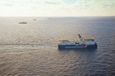 |
| The WAz fleet in operation in the southern Gulf of Mexico. |
|
The business model for exploration in the Mexican waters of the Gulf of Mexico is, by necessity, very different from that in U.S. waters. By law, all hydrocarbons in Mexican territory belong to the state, so there are no operating international oil companies, and therefore no sharing of exploration costs. In U.S. waters, multi-client surveys are common practice and allow expensive high-end technologies, such as wide-azimuth acquisition, to be used economically. By contrast, in Mexican waters, Pemex must bear the full cost of employing such techniques.
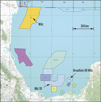 |
| Fig. 1. Various projects acquired by CGG for Pemex during this contract. |
|
Through this long-term contract for a dedicated vessel to conduct a multi-year acquisition program, Pemex was able to obtain a favorable daily rate for acquisition services, enabling it to capitalize on high-end technology provided by the 12-streamer CGG Alizé over a long period of time. Not only could the best possible narrow-azimuth 3D data be acquired in the area by the Alizé, but Pemex also later committed to acquiring a wide-azimuth survey using three additional high-end 12-streamer vessels, X-BOW, Oceanic Vega, and Viking Vanquish (October 2010 to January 2012), as well as a broadband high-density wide-azimuth survey deploying the Oceanic Vega and its sister vessel, Oceanic Sirius (2012). As both companies had worked together on several occasions in the past, this meant that a productive, successful partnership could be developed, Fig. 1.
Alizé has been employed continuously for the last three years, acquiring high-quality conventional narrow-azimuth data over large areas of the Gulf of Mexico. It was one of the first vessels in the CGG fleet to be equipped with the Sercel Nautilus acoustic positioning and streamer control system, which dramatically increased production levels and allowed it to achieve a one-day production record (at that time) of 117 sq km. Twelve 8-km streamers with 100-m separation were towed, making it, at the time, one of the largest areal arrays in the industry, and one of the largest moving objects on the planet.
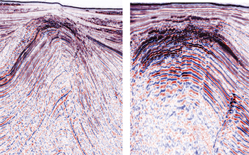 |
| Fig. 2. Narrow-azimuth data examples using Kirchhoff pre-stack time migration. Courtesy of Pemex. |
|
During this time, Alizé has acquired in excess of 65,000 sq km in nine narrow-azimuth surveys, recording data at record production rates. This is believed to be the longest continuous operation and largest seismic acquisition contract ever undertaken. This vast volume of data is being processed at the CGG processing center dedicated to Pemex in Villahermosa, at the CGG Houston Processing Center, and by other contractors. The data quality has been excellent, as seen in Fig. 2, showing examples from the extremely complex region in the southern area of the Gulf of Mexico. The long-term charter of Alizé by Pemex has enabled high-quality modern data to be economically obtained over large areas of Mexico’s Gulf waters to accelerate exploration and development plans.
WIDE-AZIMUTH ACQUISITION AND PROCESSING
In the last few years, wide-azimuth (WAz) technology has become the preferred seismic acquisition technique in the deepwater Gulf of Mexico, as it is recognized for providing superior illumination and imaging in complex subsalt areas. The technique yields improved images with sufficient quality and clarity to allow clients to identify well locations confidently for pre-salt plays, to optimize exploitation of the available hydrocarbon reserves.
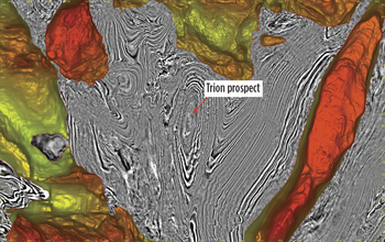 |
| Fig. 3. Depth slice through the processed wide-azimuth dataset, showing the top of the salt canopy and the Trion structure. Courtesy of Pemex. |
|
The wide-azimuth survey commissioned by Pemex was the world’s largest proprietary wide-azimuth program at the time, covering 25,000 sq km, using the largest areal spread ever deployed for this type of acquisition. The success of this project, in particular the decision to move directly from the existing 2D long-offset lines to wide-azimuth data, without an intermediate 3D survey (a bold step in 2009), has already been demonstrated by the fact that the successful prospect, Trion, was identified on the fast-track WAz data, processed by CGG and drilled only 20 months after the first shot of the WAz acquisition, Fig. 3.
The WAz survey began at the end of October 2010, using Viking Vanquish and Oceanic Vega, each towing 12 streamers of 8,100 m in length. These two towed streamer vessels, with two separate seismic source vessels, were used to acquire a survey that was well-sampled in both the offset and azimuth domains, to address the imaging challenges in the area and the need to cover a massive area in a reasonable timeframe.
The configuration used provided a multiplicity of wide-azimuth data points for each subsurface reflector, resulting in significantly higher data quality than conventional 3D seismic data acquisition. The data acquired by the WAz survey allowed substantially improved evaluation of the prolific Tertiary sandstone reservoirs of the area, which have already been proven by earlier discoveries in the Perdido Area to the north of the U.S.-Mexico border, and resulted in the drilling of a successful well.
The size of this survey can be compared to the total area of the state of Vermont, which provides an indication of the massive dimensions of the project. The WAz survey was successfully completed in January 2012, providing data of excellent quality and setting endurance records that would test any marine seismic fleet in operation. During the entire 14 months of acquisition, Oceanic Vega kept its streamers permanently deployed, another record achievement and a tribute to the carefully designed and implemented plan of preventative maintenance.
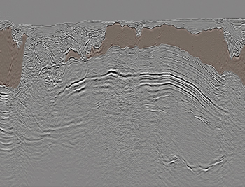 |
| Fig. 4. Data from the wide-azimuth survey showing clear images of prospects below the salt canopy. Courtesy of Pemex. |
|
The decision by Pemex to adopt wide-azimuth acquisition for its proprietary marine surveys was a significant innovation in 2009. Detailed modeling had shown that this wide-azimuth survey would be more successful than previous traditional narrow-azimuth (NAz) 3D surveying efforts, where seismic imaging is hampered by the complex salt overburden. Pemex made the decision to shoot this exclusive WAz survey in August of 2009, to improve illumination beneath complex salt canopies, but permit and contract negotiations meant that acquisition did not commence until October 2010, Fig. 4.
This complex marine operation was carefully designed, both to maximize the data quality and to match the logistic requirements of Pemex for cost-effective, timely acquisition. It implemented a new generation of sophisticated, integrated navigation systems and hydrodynamic modeling to efficiently coordinate and accurately position the streamer and source vessels. An important aspect of wide-azimuth surveying is selecting the optimum acquisition parameters, both for cost-effective operations and to ensure data quality meets processing requirements. The WAz survey had the optimum combination of illumination, sampling, data quality and speed/cost of acquisition for this particular geological environment, thanks to the extensive expertise of the contractor in designing highly effective surveys using simulation and modelling studies.
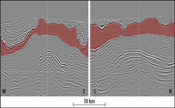 |
| Fig. 5. Inline and crossline from the wide-azimuth data, with the salt canopy indicated in red. Courtesy of Pemex. |
|
Another critical component of the success of these surveys was the processing and imaging of the data. CGG delivered a pre-stack depth-migrated fast-track volume of the whole survey four months after final acquisition, using a comprehensive package of true 3D processing algorithms designed especially to exploit the azimuthal information contained in wide-azimuth data. These included 3D SRME, wide-azimuth regularization and tomography, as well as RTM and an advanced toolbox of velocity modeling techniques specifically for subsalt imaging, and, hence, ideal for the complex salt tectonics found throughout this area, Fig. 5.
BROADBAND HIGH-DENSITY WIDE-AZIMUTH ACQUISITION AND PROCESSING
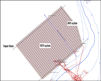 |
| Fig. 6. Planned project map over development and exploration fields. |
|
Broadband techniques, which provide extended bandwidth, are producing some of the most exciting marine seismic imaging results. Pemex acquired the first broadband, high-density, wide-azimuth survey specifically designed for the development of extra-heavy oil fields in the region. The survey was designed to use state-of-the-art recording procedures for the highest spatial resolution in inline and crossline directions, as well as the highest temporal resolution in terms of the broadest frequency bandwidth. This was a dual-purpose development and exploration project, covering 1,971 sq km for development fields, and 801 sq km for exploration purposes, Fig. 6.
The pre-existing data quality in the area was poor, lacking resolution, due to limited bandwidth; missing fault-plane definition, due to poor velocity control; and suffering from low signal-to-noise ratio and multiple interference. It was determined that high-density, wide-azimuth data were required to resolve critical imaging issues for existing prospects, and allow optimal reservoir characterization to assist field development engineers. Acquisition challenges included the fact that part of the survey location is a shallow water area, with limited sea space to turn, and that there were several obstructions (both known and unknown), as well as tanker movements to and from FPSO.
The BroadSeis high-density wide-azimuth survey was acquired in the spring and summer of 2012 by Oceanic Vega and Oceanic Sirius, using the same four-source × 24 streamer configuration that was employed on the WAz survey, but in this case additional sail lines were interleaved to produce smaller crossline bins (25 m rather than 50 m) and the shotpoint interval was halved to 18.75 m. This acquisition design and processing would produce a final bin of 12.5 × 25, with a fold of 725. BroadSeis streamer profiles were deployed, to create receiver ghost notch diversity and enable broadband (2.5–150Hz) acquisition.
Continuous recording was employed to enable a minimum useful record length of 7 sec to be acquired, even in the deepwater areas. By using this technique, it is possible to overlap the shot records, so that deep data (beyond 7 sec) can be recorded from one shot while the next shot energy is travelling through the water column, thus enabling data to be acquired down to 9 seconds in the deepwater area, even with a short, 18.75-m, shotpoint interval. By overlapping the data through the water column, the only interference from the following shot is the direct arrival energy, which is easily removed in processing. This was one of the first production surveys to employ this technique, which requires the use of the latest Sercel SEAL 428 recording system.
Since the survey location is a busy producing field, there were a number of obstructions, including FPSOs with large exclusion zones in the south of the area, which meant that this part of the survey could not be acquired as planned. Unfortunately, the two highest-priority data locations, the short-term drill locations which are of great interest to the Pemex development group, are on the edge of this area. To acquire data in the southeastern portion of the survey, with maximum coverage in terms of both offsets and azimuths at these locations, while maintaining a safe distance from the FPSOs and drilling rigs, it was necessary to change both the spread configuration and shooting direction in this area.
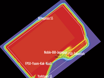 |
| Fig. 7. Fold on completion of both “normal” and “oblique” programs. |
|
To add to the acquisition challenges, a jack-up drilling rig arrived on site with no notice, preventing Oceanic Sirius from being able to safely acquire data to the northeast of the obstructions, due to the proximity of the line turn area. Since this was not a priority area, as much data as possible were acquired to obtain the best coverage without compromising safety or revising the configuration any further, Fig. 7.
Acquisition of this complicated survey was facilitated by the good relationship between Pemex and CGG, and the cooperation and collaboration of all concerned. Pemex arranged a number of tanker-free time slots at FPSO Yuum Kak Naab and FSO Takuntah. Close liaison between the seismic vessel manager, the offshore vessel manager and the tanker tug captain enabled safe acquisition of the data in this busy area.
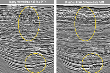 |
| Fig. 8. BroadSeis HD-WAz comparison, showing improved resolution and higher definition, as well as greater geological character and layer differentiation. Courtesy of Pemex. |
|
 |
| Fig. 9. BroadSeis HD-WAz comparison showing better fault plane vdefinition. Courtesy of Pemex. |
|
The final processing of the BroadSeis high-density wide-azimuth data is still ongoing, but the preliminary results show considerable improvement over previous data in the area. Fair comparisons are difficult, as the new data are high-density, wide-azimuth and broadband, whereas the legacy data are conventional narrow-azimuth, but the new data show higher definition in the shallow section, better fault planes and better deep penetration, Figs. 8–9.
A fully integrated reservoir-oriented processing sequence is being performed on this data set. The initial processing includes shallow-water demultiple, BroadSeis 3D SRME, high-resolution Radon demultiple and phase-only Q-compensation. 3D common-offset vector binning has been performed, and the data regularized and interpolated onto a 12.5 × 25-m grid. The parallel reservoir processing flow includes seismic rock property analysis, well-to-seismic ties (on the fast-track data) and modeling of synthetic gathers to match with the processing.
Correct imaging in such a complex area is critical, so the latest technology is applied to obtain the best possible subsurface images. Final seismic data volumes will include both time and depth migrations, and the reservoir products will include acoustic, stochastic and azimuthal inversion products to provide a detailed analysis of the reservoir for the derivation of high-quality reservoir models and production scenarios.
By building a long-term partnership with a major geoscience contractor, Pemex has been able to employ the latest technology to help identify and exploit Mexico’s offshore hydrocarbon reserves. The worldwide experience of CGG, combined with deep local knowledge of the Gulf of Mexico, has been instrumental in achieving a successful exploration partnership, providing modern 3D seismic data over vast areas of the Mexican waters of the Gulf. The huge wide-azimuth survey provides optimal illumination of the complex salt and subsalt features of this area, and with the discovery at Trion-1, these investments are already starting to pay off. With the acquisition of the broadband high-density wide-azimuth survey—arguably the most advanced marine seismic dataset to have been acquired anywhere at the time—Pemex has demonstrated its commitment to the use of the latest technology to support the development of the recently discovered heavy oil fields north of the Ku-Malob-Zap complex—currently the largest oil-producing field in Mexico. 
|


