Geostatistical inversion transforms subsurface understanding across the Americas
As the oil and gas industry further seeks to reduce near-field exploration and development risk, CGG has seen an increase in operators applying geostatistical seismic inversion technologies to their reservoir units to further enhance subsurface understanding. The challenges they face are unique to the individual basins, but they nevertheless share a common aim of deriving additional reservoir characterization information from seismic data and an assessment of the uncertainty.
Whether the target formation is composed of thin-bed, discontinuous heterogeneous sand reservoirs, or carbonate reservoirs sandwiched between overlying salt and underlying basalts, traditional deterministic inversion workflows are limited to the resolution of the input seismic data, and do not provide uncertainty estimations away from well control.
GEODATA INTEGRATION
To address these challenges, CGG developed ResPack HD as part of the company’s GeoSoftware technology package. This innovative solution offers a workflow for geoscience data integration, such as well log data, seismic data and geological understanding. These data and integrations are used to create models that predict lithofacies and reservoir rock properties more accurately, not only at well locations but crucially between the wells. Most notably, CGG’s clients have seen the uplift the ResPack HD workflow can bring, compared to traditional deterministic methods, by providing most probable reservoir properties and uncertainty estimation at a scale of 5 to 25 ft, compared to 50 to 125 ft previously. This ability to enhance reservoir characterization interpretation has helped operators identify potential exploration and development areas in challenging and less favorable geology.
ResPack HD advantage. Standard non-geostatistical seismic interpretative solutions (deterministic solutions) provide no detail beyond the seismic resolution and usually lack other data integration. By their very nature, these technologies, alone, are unable to resolve thin (feet/meter-scale) lithofacies or quantify thin-bed rock properties. ResPack HD integrates all available geological, geophysical, rock physics and engineering information of varying degrees of spatial resolution and lateral coverage to:
- Define a probabilistic model of the subsurface represented by probability density functions (PDF)
- Generate a number of highly detailed, independent and identically distributed reservoir model realizations (facies and reservoir properties) from this probability model, all consistent with the available conditioning input data, and
- Assess uncertainties, based on geological criteria of the various models to improve numerical reservoir models and/or take operational decisions through risk analysis.
Input data preparation is paramount to achieving an accurate probabilistic model, especially of the well data. Here, the company’s team of experienced petrophysicists work toward editing and reviewing the wireline log data, whilst incorporating “real rock” data to constrain their petrophysical outputs.
Methodology. The ResPack HD workflow used in this work is a combination of the Bayesian scheme and Markov Chain Monte Carlo (MCMC) technique, which is housed within CGG GeoSoftware’s Jason RockMod software. The inversion process incorporates data from various disciplines to identify the rock and reservoir properties that are consistent with statistics, prior information and the seismic. It also allows for multiple equi-probable models that are consistent with the input data.
To start the process, a 3D stratigraphic or structural grid is built from interpreted seismic horizons and faults. The grid defines the stratigraphy (conformal, truncated and proportional) of different layers and is typically used as a framework to confine the populated properties within its microlayers during the inversion process. Secondly, prior joint probability density functions (PDF), and variogram models of facies and elastic properties are estimated from lithology and elastic wireline logs as well as any other additional geological information. This geostatistical model (PDF and variograms) controls the spatial distribution of reservoir properties between wells.
Thirdly, ResPack HD starts with a series of simulations from a prior geostatistical model and a candidate facies volume populated with elastic properties. These volumes are checked against the seismic by creating synthetic partial stacks via a forward modeling process that are validated against seismic residuals. To obtain realizations from the posterior PDF of facies and elastic properties, an MCMC algorithm is used to make random changes iteratively to the components of the reservoir model and accept or reject the changes to better approximate the posterior PDF, using the magnitude of seismic and prior information.1
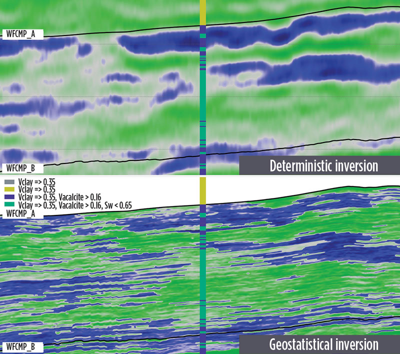
The workflow typically ends with a process called co-simulation. The goal of co-simulation is to build a multivariate statistical relationship to simulate the reservoir properties from the previously inverted elastic properties and facies realizations. The final step in the workflow involves “ranking” or sorting the multiple realizations, based on a selective criterion that provides a measurement of uncertainty. This objective criterion is defined and applied to all the realizations or scenarios to obtain a value per realization. The mean and standard deviation can then be determined along with quartiles from the chosen ranking scenarios (e.g. p10, p50 and p90). Figure 1 shows a lithofacies cross-section comparison between a standard deterministic inversion (upper image) and the equivalent ResPack HD interpretation (lower image), which is, in fact, the most probable facies of all lithotype realizations calculated.
CASE STUDIES
Four case studies from recent ResPack HD projects completed across the Americas provided insights to unique reservoir characterization challenges.
Greater Permian basin. The greater Permian basin is a vast area of the southern U.S, spanning 86,000 mi2 of West Texas and southeastern New Mexico. The basin is divided into the Midland basin in the east and the Delaware basin in the west, separated by the central basin platform. The application of ResPack HD is well-suited to this complex geological environment. The prolific reservoir units of the Wolfcamp and Bone Spring formations contain many fine-bed vertical facies changes together with multiple lateral heterogeneities and discontinuities, all impacting spatial and vertical reservoir quality.
The first example of the application of ResPack HD took place in the Midland basin, where our client was generating lateral well development plans, targeting the fine-bed and heterogeneous calciturbidite facies of the Wolfcamp A formation. The company’s reservoir characterization team had already completed a deterministic inversion over the interval of interest in 2016, as part of the company’s Hobo 3D multi-client seismic dataset, which identified the vertical and lateral cyclicity of these lithologies through the separation of VP/VS and P-impedance.
Similar carbonate volumes have been used previously by operators to identify reservoirs within the vicinity of the eastern Midland basin shelf. However, after a review of core data in the area during a subsequent 2019/2020 study, it became evident that the traditional deterministic inversion had limitations in characterizing the Wolfcamp complexity and, ultimately, the discrete reservoir compartments distributed throughout the study area. This knowledge is crucial for the identification of future landing zones for lateral well development to ensure maximum reservoir contact, which can, in turn, lead to optimum stimulated rock volume (SRV) and ultimately higher hydrocarbon production yields.
When the HD technology was applied subsequently to the dataset, to enhance the lithofacies probability across the study area, it not only enabled our client to identify higher-porosity carbonates, but also to understand their continuity and connectivity. The operator now had a refined reservoir insight, in order to better plan future lateral well trajectories, with greater certainty, and compare the results of log data with the geostatistical lithofacies volumes. Figure 2 shows a cross-section through the Wolfcamp A, where the colors represent different lithofacies compositions, as defined by volume of clay (Vclay) and volume of calcite (Vcalcite). The “blind well” was used as a QC comparison to check the validity of both the vertical and lateral ResPack HD results. At the time of writing, the lateral wells within this study area have not been completed, which means no correlation can yet be made between well placement, SRV and hydrocarbon production.
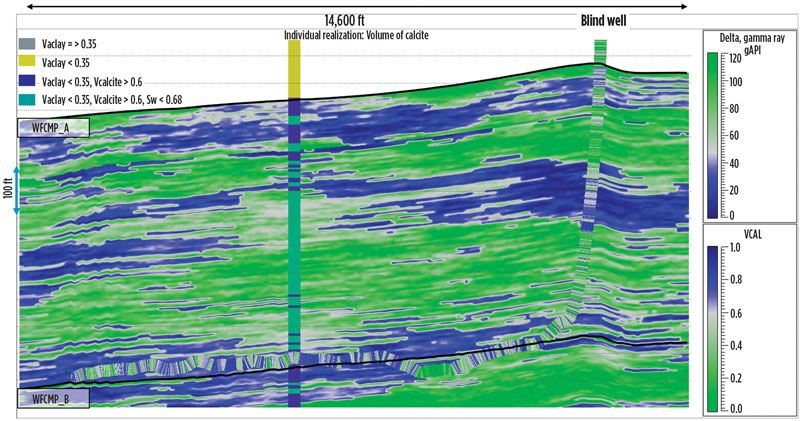
A second Permian basin example comes from a recent ResPack HD project completed on the company’s Avalon 3D multi-client seismic data in Reeves County within the Delaware basin. The geology poses challenges for seismic acquisition, due to the complex near-surface velocity and receiver coupling issues and, for this example, the low reflectivity of the Wolfcamp formation, due to its lithological composition of siltstones and mudstones, and the energy-absorbing Bone Spring formation above it. The Wolfcamp formation within this area is a hydrocarbon resource target, consisting of fine-bed heterolithic lithologies. Faced with these challenges, traditional seismic inversion techniques have struggled to extract reservoir properties at the Wolfcamp level. Figure 3 shows a comparison between a deterministic inversion and geostatistical inversion from ResPack HD over the Wolfcamp and Bone Spring interval from Reeves County.

The ResPack HD results, particularly in the Wolfcamp formation, provide additional rock property insights at a much higher resolution than the deterministic inversion approach. Key to any probability analysis is QC’ing the result against known data and interpretations. In this project, blind wells were added to the database after the initial model build and high correlation was observed. This gave our client additional confidence in the Res-Pack HD results, leading to more informed drilling decisions.
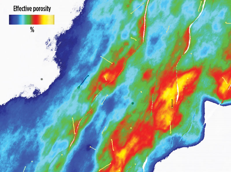
Anadarko basin, Oklahoma. The Anadarko basin covers an area of approximately 50,000 mi² through western Oklahoma and the northeastern Texas panhandle. The Mississippian-aged Meramec Group within the STACK play of the Anadarko basin shows a strong shift in depositional styles across the basin from NE to SW, resulting in a change from a carbonate system to a siliciclastic system. Understanding the stratigraphic and facies changes is an important factor for characterizing horizontal and lateral changes between dominantly carbonate and siliciclastic intervals. For example, the carbonates are often susceptible to diagenetic alteration, resulting in a high variability of porosity values laterally across the area, making correlation challenging.2
Figure 4 shows the average porosity maps of the entire Meramec A interval, from ranked ResPack HD effective porosity scenarios (p10, p50, p90) and, for comparison, a density-porosity map interpolated from well data that were not considered for the ResPack HD workflow, due to their lack of P and S sonic log measurements. Figure 4 covers only a small portion (approx. 3 x 3 mi2, referred to as “area of interest”) of the whole 295-mi² project, and only one of the 13 wells utilized in the ResPack HD workflow is located within this smaller area, as displayed on the ranked porosity maps (p10, p50 and p90). The p10 represents the least optimistic case; the p50 represents the median case scenario, where 50% of the realizations show less average porosity, and the p90 is the most optimistic scenario, with only 10% of the realizations predicting higher average porosity.
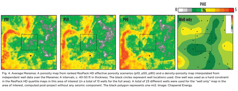
To validate the results, a set of 23 well data points was used to create a “well only” map, Fig. 4. To construct this map, average porosity values were computed at each 23-well location in the Meramec A interval before being interpolated by normal kriging. As mentioned earlier, those wells were not used in the workflow, hence, the “well only” map can be seen as a pure blind well validation. The map follows the same trend as the porosity map, but the seismic-driven ResPack HD result shows more detailed stratigraphic features. In addition, the multiple realizations generated from ResPack HD allowed for uncertainty assessment. This series of maps clearly illustrates the number of details brought by the seismic through the workflow, and the same features are observable when looking at the well interpolation.
These results illustrate the benefits of using the new modeling technology for unconventional play reservoir characterization, as well as for well planning and de-risking of drilling locations, especially in the case of multiple, stacked horizontal wells targeting different intervals.
Santos basin, Brazil. The application of ResPack HD to offshore Brazilian oil fields is growing in popularity, owing to the challenges associated with obtaining formation properties from pre-salt reservoirs via traditional deterministic inversion approaches. This example presents our latest work completed for Petrobras within Tupi oil field (formerly known as Lula field).
Tupi field, in the central part of the Santos basin, is one of the giant fields of the pre-salt reservoirs and has become one of the largest oil producers for Brazil.3 The carbonate reservoirs of the Barra Velha formation within Tupi field show significant lateral and vertical variability in rock properties. The work completed by CGG, as presented by Kneller,4 in collaboration with Petrobras, demonstrates that geostatistical inversion provided a clearer reservoir picture within the pre-salt environment. The main facies defined in the area are clean and argillaceous carbonates, characterized by high uncertainty in elastic property values and high lateral variability. Additionally, the overlying salt layer limits the illumination and penetration of the seismic signal. Consequently, a deterministic inversion does not make it possible to distinguish reliably between clean and argillaceous reservoir rocks, whereas the ResPack HD methodology provides an effective solution for reservoir characterization.
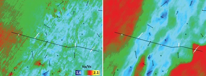
Figure 5 compares Vp/Vs ratio maps obtained from deterministic (left image) and geostatistical (right image) inversion for one of the stratigraphic units within the Barra Velha formation. The Vp/Vs ratio property is the main indicator of argillaceous limestones within this reservoir. One of the main benefits of using a ResPack HD geostatistical inversion for this field is the ability to integrate additional information into the inversion workflow, such as geological maps and data, allowing for the delivery of reservoir properties. The achieved separation in facies made it possible to generate further effective porosity volumes within the clean reservoir carbonates, using co-simulation techniques, Fig. 6. The results improved the mapping of the transition between clean reservoir carbonates and argillaceous carbonates, which made it possible to de-risk future production and injection well locations within the Barra Velha formation.
CONCLUSIONS
By applying the ResPack HD geostatistical inversion solution to enhance seismic reservoir characterization, CGG continues to generate added value for its clients. The case studies presented give an insight into some of the challenges our clients face in a wide range of geographic and geological settings. Through implementation of the ResPack HD workflow, exploration and development activities can be de-risked significantly to help better quantify reservoir detail and significantly reduce subsurface uncertainties.
ACKNOWLEDGEMENTS
The authors would like to thank Sinclair Oil & Gas, Chaparral Energy, Petrobras and CGG Multi-Client for permission to publish this article and associated images. They also thank management at CGG GeoSoftware for allowing the use of Jason RockMod for geostatistical inversion.
REFERENCES
- Marquez, D., D. Saussus, R. Bornard and J. Jimenez, “Incorporating rock physics into geostatistical seismic inversion–A case study,” EAGE 75th Conference, 2013.
- Shelley, S., G. M. Grammar and M. Pranter, “Reservoir characterization and modeling of a subsurface Meramec analog from a quarry in northeastern Oklahoma,” Oklahoma City Geological Society, The Shale Shaker, p. 224-243, September-October 2017.
- Boletim da Produção de Petróleo e Gás Natural, February 29, 2020.
http://www.anp.gov.br/arquivos/publicacoes/boletins-anp/producao/2020-01-boletim.pdf - Kneller, E., L. Teixeira, B. Hak, N. Martinho Cruz, T. Oliveira, J. Marcelo Cruz, and R. Santos Cunha, “Challenges and solutions of geostatistical inversion for reservoir characterization of the supergiant Lula field,” EAGE petroleum geostatistics, 2019.
- Reinforcing safety as global activity revitalizes offshore (August 2025)
- Harbour Energy successfully appraises Kan discovery in Mexico, increases estimate to 500 MMbbl of oil-in-place (June 2025)
- What's new in exploration: Gulf of what? Mar del Norte ~1519? Gulf of North America? (March 2025)
- Oil and Gas in the Capitals: Non-traditional countries attract new and important investments (December 2024)
- Trailblazing onshore oil and gas exploration in Ukraine (December 2024)
- Global activity looks solid and is increasing (September 2024)
- Subsea technology- Corrosion monitoring: From failure to success (February 2024)
- Applying ultra-deep LWD resistivity technology successfully in a SAGD operation (May 2019)
- Adoption of wireless intelligent completions advances (May 2019)
- Majors double down as takeaway crunch eases (April 2019)
- What’s new in well logging and formation evaluation (April 2019)
- Qualification of a 20,000-psi subsea BOP: A collaborative approach (February 2019)

