Integrated datasets hold the key to unravelling petroleum prospectivity
The advent of broadband seismic acquisition, combined with new deghosting/imaging algorithms and exponential increases in computer processing power, has generated improved seismic images. These advances give scientists an opportunity to re-evaluate a region’s subsurface geology. The new interpretation, combined with geology-based datasets, is now being studied in conjunction with modern and historical seismic data, to fully understand petroleum prospectivity.
IDENTIFYING DATASETS
A range of innovative methods has been developed to reduce key uncertainties posing obstacles to future exploration, significantly reducing risk. CGG is generating integrated geological studies for a number of multi-client seismic programs across the globe, including the Australian North West shelf, the South Atlantic conjugate margin, Mexico, the Banda collision zone in Southeast Asia, UK North Sea, Norwegian Sea and onshore the U.S.
These integrated studies are designed to deliver a comprehensive geoscience package that can include a combination of: 1) regional geology; 2) prospectivity reviews; 3) potential field data; 4) seep studies from satellite imagery; 5) well data packages (including dry hole evaluation and re-analysis/new analysis of biostratigraphy); 6) sedimentology/geochemistry analyses; 7) paleo-environmental imaging; 8) seismic reservoir characterization; alongside ultramodern seismic data volumes.
The aim is to properly combine these value-added technologies to save operators time and energy, which can be reinvested into developing new play models, identifying prospects, or determining how to enhance current production. Using an established multi-client seismic database, we can demonstrate how the integration of geophysical and geological datasets can reduce cycle time, validate accuracy of the data, and provide greater understanding of specific problems related to a region’s petroleum geology. The multi-faceted analysis reduces exploration risks significantly in existing plays and provides leads for developing new prospects.
BROADBAND SEISMIC
Arguably the most significant seismic technology developed in the last decade, broadband seismic has contributed significantly to our knowledge of sedimentary basins and their prospectivity. Broadband’s sharp wavelets, delivered by high frequencies, provide increased detail and resolution to help detect subtle and thin stratigraphic variations. This technique can be used in near-surface imaging for geohazard identification, and it also enables detailed velocity modeling. Low frequencies reduce sidelobes, so that seismic events are seen as discrete peaks or troughs for clearer interpretation. This assists with the identification of true geological features, improves facies differentiation, allows deeper signal penetration below complex overburdens, reduces cycle skipping in full waveform inversion (FWI) velocity modeling, and provides more reliable and quantitative inversion results.
New broadband multi-client seismic surveys are acquired using CGG’s BroadSeis variable-depth streamer solution. In suitable geologies, this technique is combined with a synchronized multi-level broadband source, called BroadSource, to extend the spectrum to higher frequencies by filling in the source ghost notch and providing over 6 octaves (2-200 Hz) of seismic signal. Most of these surveys are being developed into integrated geoscience studies, which benefit from using the best possible seismic images and reservoir data that are ready for analysis with minimal pre-conditioning.
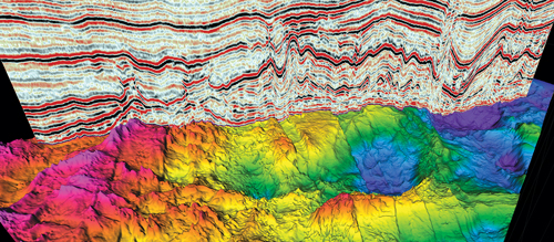
Offshore Brazil. In the Santos basin, broadband imaging of several multi-client surveys has improved resolution dramatically below the late Aptian evaporites, an environment that has provided some of the largest oil discoveries in the last decade, including Lula field. One of the best examples of this is in the South Atlantic, where seismic from the Santos basin provides a clear image of both the pre- and post-salt successions, Fig. 1. A new broadband survey will be acquired later this year, and it will bridge the existing surveys, which will be reprocessed and combined with the new data to deliver a vast, contiguous data set. On the other side of the conjugate margin, a large broadband multi-client survey in the Gabon South basin is delivering similarly improved images. It will be the keystone of a major integrated geoscience study.
Large multi-client surveys offer the industry a cost-effective means of acquiring high-quality broadband data, compared to proprietary surveys. Costs can be shared, and larger surveys provide a better overall view of the prospectivity than is generally the case with smaller, proprietary surveys. Access to large surveys, especially those forming parts of integrated geoscience studies, in both mature and frontier basins, enables operators to reduce exploration risk and shortens the time required to drill the first test well after being awarded an exploration license. Additionally, proprietary surveys confined to small blocks often have incomplete data coverage of a basin. Their acquisition is inefficient, and therefore more expensive, due to the disproportionate time spent on line turns, building up to full-fold and making allowances for migration fringes. Contrasting acquisition parameters and azimuths also can make “regional” exploration more difficult.
GEOSCIENCE PROGRAMS
Even in mature areas, like the North Sea and Norwegian Sea, significant challenges remain, where the improved imaging from new broadband seismic helps provide answers. This is especially true where this forms part of an integrated geoscience project.
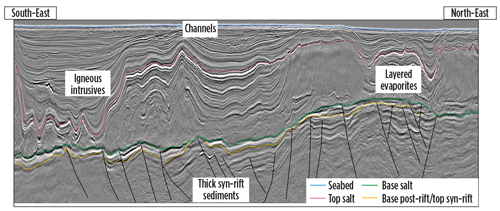
North Viking Graben. Covering more than 36,000 km2, this survey spans the eastern area of the prolific Viking and Sogn grabens and has been extended to include the central and western parts of the Viking Graben, across and into, the UK shelf. The survey covers the supergiant Troll field, and other large oil fields, including Statfjord, Gullfaks, Snorre and Oseberg. It also covers Gjøa, Fram, Vega, and the recent Skarfjell and Grosbeak discoveries. When completed, the larger North Viking Graben (NVG) study will form an integrated geoscience program, including geological context, potential fields, satellite imagery, a high-quality well package, a prospectivity review, seismic reservoir characterization and biostratigraphy, and sedimentology and geochemical data, as well as reservoir-quality, broadband seismic data.
In spite of its mature status, there are still significant challenges in the Viking Graben region, such as mapping the Upper Jurassic sandstone, and areas where it has been affected by erosion. It is necessary to understand the complex petroleum migration system and late westward tilting of the entire region, which resulted in remigration of hydrocarbons and the formation of new traps and leakage from others. Remigration of gas is a very rapid process, while remigration of oil requires millions of years to equilibrate. This suggests that large volumes of oil might be present in stratigraphic, structural or dynamic traps in this region.
Other challenges relate to the lower Cretaceous Agat formation, a well-known play within the region, with proven gas condensate-bearing sandstones. Thought to be mainly a stratigraphic play, the principal risks outlined by the Norwegian Petroleum Directorate include identification and mapping of reservoir thickness/quality, and trap definition. Therefore, to successfully target this play, high-resolution seismic data, provided by the NVG survey, need to be integrated with a detailed knowledge of the occurrence of the sandstone, and supported by seismic reservoir attributes to determine its prospectivity.
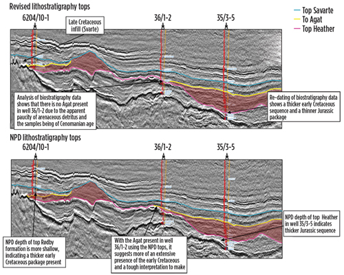
Figure 2 shows the results of a re-analysis of biostratigraphic data in an integrated study, using data from three wells across the Måløy slope, offshore Norway. Where regional inconsistencies were inherent in the original dataset, the re-evaluation improved consistency and accuracy of formation tops. This documented a thinner Jurassic interval than previously picked, while it enhanced our ability to identify the Agat formation. When the three wells are tied to improved broadband seismic data, a much more refined interpretation of the lower Cretaceous play is possible, providing improvements in locating reservoir sequences and enhanced understanding of this gas condensate-bearing sandstone. Subsequently, prospectivity is illuminated further by combining the reservoir-related attributes derived from the reservoir-oriented amplitude versus offset (AVO) and acoustic inversion volumes generated as part of this study.
REPROCESSING LEGACY DATA
An integrated geological approach frequently has its greatest impact in frontier basins, where seismic data have much sparser coverage and are often of lower resolution and quality than today’s ultra-modern images. Here, the challenge is to upgrade data quality and reduce the number of poorly constrained play concepts by using every possible geological and geophysical data source. A key component of this approach is the reprocessing of legacy seismic data (Fig. 3), using the latest imaging techniques, which were developed for more recently acquired data, including broadband.
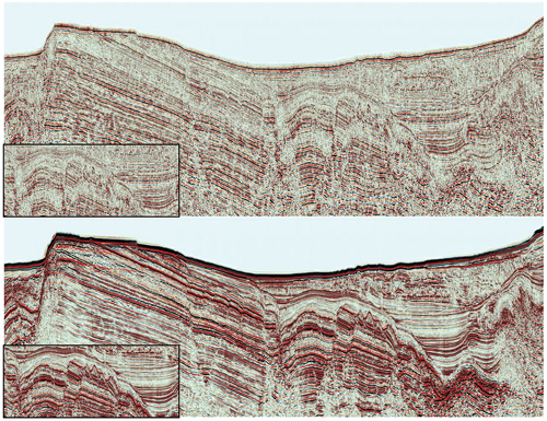
For example, deghosting (removing the source and receiver side ghosts) produces broader bandwidth data and can significantly improve image quality. By combining this more coherent dataset with any other available geoscience information, both structural and stratigraphic traps can be identified readily. In addition, zero-phasing allows us to identify amplitude anomalies and other direct hydrocarbon indicators (DHI) with greater confidence. Additional identifying technologies, such as angle stacks, gathers, and velocity databases are generated routinely alongside the reprocessed seismic data.
The enhancement and integration of legacy datasets provides exploration companies with regionally extensive, reliable, and cost-effective workstation-ready projects. These projects can be used as building blocks to develop new frontier and regional exploration programs, and high-grade acreage, for further exploration. Further risk limitation can be achieved by using this information to determine acquisition and processing issues likely to be encountered by new surveys, ensuring optimum survey design. For example, depth-to-economic basement, stratigraphic columns, structural complexity, expected impedance contrasts in the overburden, multiple generators and significant structural orientations all can be determined. Furthermore, these datasets also can be used for designing non-seismic acquisition programs including gravity, magnetic, satellite slicks or drop cores.
HYDROCARBON SEEPS
Another valuable technique for determining a region’s petroleum prospectivity is the documentation of oil seeps. Both on and offshore, seeps provide a valuable tool for exploration in frontier regions, reevaluating the prevailing paradigm for “rejected basins” and refining subsurface geological models in more mature areas. These visible seeps have led to the discovery of many of the world’s important oil- and gas-producing fields.
Oil and gas, from either mature source rocks, or leaking reservoir rocks, migrate through the subsurface through porous and permeable pathways (e.g. faults, mud volcanoes, pipes and pockmarks) to the surface. Offshore, oil-coated gas bubbles escaping from the seabed burst at the sea surface, forming a “pancake” of oil. Sustained seepage results in the coalescing of these pancakes into slicks, which dampen wind ripples on the sea surface and can be observed from space.
The company’s satellite mapping group uses synthetic aperture radar (SAR) images, selected at optimum sea conditions for slick identification, to cost-effectively search for hydrocarbons on a worldwide basis. Surface slicks are interpreted based on size, shape, distribution pattern and repeatability, allowing naturally occurring seeps to be differentiated from pollution. The slicks are then ranked to give an indication of the confidence in their origin.
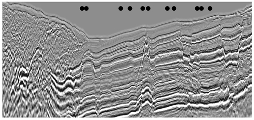
Satellite slicks that can be linked to potential leakage points, such as pockmarks and faults seen on seismic data, provide a powerful tool for building confidence in the occurrence of a working petroleum system. Figure 4 shows the occurrence of satellite slicks above part of the 14,000-km 2D BandaSeis broadband survey acquired over an area of complex geology at the collision zone between continental Australia and the Indonesian archipelago. Here, the acquisition has, for the first time, clearly imaged the structural complexity and, crucially, the potential migration pathways of generated hydrocarbons.
PALEOENVIRONMENTAL RECONSTRUCTION
Proof of the occurrence of a working hydrocarbon system is only one of several elements required to successfully locate potential hydrocarbon accumulations within a basin. It is equally challenging to understand the likely depositional environment, which will determine the probable play fairways, reservoir properties and potential field sizes.
Reconstruction of the paleo-depositional environment from seismic data has, historically, been achieved by extracting time or isoproportional slices. Today, a number of more sophisticated methods exist to efficiently extract a greater density of surfaces that better parallel subsurface reflection events (i.e. depositional or erosional surfaces). The company’s InsightEarth software is one such method to map these surfaces. The software module reveals much improved detail and clarity of the paleo-depositional environment, compared to historical methods.
One of the main advantages for the interpreter is the ability to rapidly visualize the stack of surfaces making up the subsurface geology. The stratal slices are converted to a book volume that can be reviewed by panning down (or up) through each surface, in the same way as with traditional time or depth slices. Subtle changes in depositional environment can be detected rapidly when scanning through the volume; the process is more efficient than using conventional approaches. Subject to the appropriate depositional environment, channels, levees, terminal fan lobes and other stratigraphic features are depicted as originally deposited.
Stratal volumes help to reveal the depositional environment, but this is just the first step in the process to understand the hydrocarbon system and its prospectivity. Each of the different sediment facies observed on the stratal slice snapshot has its own unique dominant frequency. Frequency decomposition of the stratal volume and re-blending of three chosen frequencies is the next step in the process.
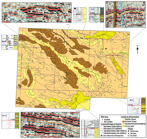
In mature areas, such as the North Sea, integration of re-blended, frequency-decomposed stratal slices with existing well data, at the same stratigraphic level, can improve the understanding of unsuccessful wells. Integration and analysis of well data, specifically information on depositional facies obtained from wireline log interpretation and its amalgamation with core and other well data, can be used to construct seismically-driven depositional maps, Fig. 5.
The depositional environment, inferred from the well data, is then used to constrain the sedimentological interpretation of the stratal slice imagery. By applying this method, it is easier to differentiate those wells that successfully penetrate the main reservoir in channel sands from those that have penetrated poorer reservoir-quality facies. The process aids future drilling plans with better prediction of reservoir sweet spots, reduces exploration risks, and increases the chances of commercial success.
COMBINING GEOSCIENCES IMPROVES ACCURACY
Integrating multiple geoscience disciplines has advantages, even before the seismic data are acquired. Incorporating knowledge of the geology into the survey design means that the optimum data can be acquired with the ideal offsets and azimuths to image the target. In some cases, innovative new acquisition designs have been developed, using new modeling techniques to test various configurations before committing to acquisition. Collaboration with the people who will eventually use the data, for example, in interpretation or reservoir characterization, means that better data can be acquired and processed. Understanding the broader picture enables each component to be optimized, to ensure the best possible result.
The same collaborative multi-disciplinary approach can then be applied to the acquired seismic data. Here, we have shown several examples of how targeted integration of geology with the seismic data validates the data and reveals answers to some of the key uncertainties relating to the petroleum system of specific areas. On a larger scale, these integrated studies are designed to provide an in-depth understanding of the petroleum system and deliver tailored solutions to reduce the time, key risks and challenges associated with exploration, so that more successful wells can be drilled, and energy can be focused on finding new plays. ![]()
ACKNOWLEDGMENTS
The authors would like to thank CGG Multi-Client & New Ventures for permission to publish this article and associated images.
REFERENCES
- Amundsen, L., et al., 2014, Broadband Seismic Technology and Beyond. Part VIII Broadseis in Exploration: GeoExpro, March 2014, 52-54.
- Horstad, I., Firth, J. and Schakel, M., 2014, Experiencing the full bandwidth of energy from exploration to production with the Art of BroadSeis, First Break, June 2014.
- Duval G., 2012, How broadband can unlock the remaining hydrocarbon potential of the North Sea: First Break, 30, 85-91.
- Mann, J., 2013, Broadband seismic imaging improves subsurface mapping of Santos Basin pre-salt reservoirs: World Oil, September 2013, 33-38.
- Michel L., Lafet, Y., Sablon, R., Russier, D., and Hanumantha R., 2012, Variable Depth Streamer – Benefits for Rock Property Inversion: 74th EAGE Conference & Exhibition, Copenhagen.
- Siliqi, R., Payen, T., Sablon, R., and Desrues, K., 2013,”Synchronized multi-level source, a robust broadband marine solution”, SEG Technical Program Expanded Abstracts 2013: pp. 56-60.
- Duval G, and Firth J., 2015, G&G integration enhances acquisition of multi-client studies offshore Gabon: World Oil, July 2015, 57-61.
- Horstad, I., Frantzen, E. and Firth, J., 2014, Horda survey heralds new strategy, Seismic Profile, Issue 9, 2014.
- NPD: http://www.npd.no/en/Topics/Geology/Geological-plays/Norwegian-Sea/Lower-Cretaceous/
- Mann, J., 2015, Horda Platform: Exploring the Cretaceous: GeoExpro, 12 (3) 80-84.
- Spofforth, D.J.A., 2015, New Frontier Exploration in East Africa: using legacy data to reduce uncertainty: Seismic Profile, Issue 11, 2015.
- Link W., 1952, Significance of oil and gas seeps in world exploration, AAPG Bulletin, 36 (8), 1505-1540.
- Baillie, P., 2015, Using broadband in the Banda Arc: Oilfield Technology, January 2015, 24-29.
- The reserves replacement dilemma: Can intelligent digital technologies fill the supply gap? (March 2024)
- What's new in exploration (January 2024)
- Dallas Fed: E&P activity essentially unchanged; optimism wanes as uncertainty jumps (January 2024)
- Quantum computing and subsurface prediction (January 2024)
- What's new in exploration (September 2023)
- Machine learning-assisted induced seismicity characterization of the Ellenburger formation, Midland basin (August 2023)

