Geosteering solutions land wellbore and maintain lateral in deepwater target
At a deepwater (7,000 ft) location in the Gulf of Mexico, an operator was struggling to identify the approaching reservoir top during the landing section due to complex geology with lateral variation and seismic uncertainty. The primary challenges for landing the curve included structural instability and a low-resistivity environment. Precise wellbore placement and correct borehole trajectory were critical. Any failure to execute per plan would cause a geological sidetrack, costing millions of dollars in extra rig time.
Two different structural scenarios, based on seismic interpretation, provided additional challenges: 1) a relatively gentle dip angle; or 2) a steeper dip angle on the landing approach. Each geological scenario required a different method to land the wellbore. Additionally, log correlation with offset wells lacked the required logging-while-drilling (LWD) responses, due to lateral variances, making it difficult to identify marker beds and increased uncertainty in the models used to predict geology.
To reduce risk and geological uncertainty in landing the borehole, proactive geosteering along with a bed boundary mapper system were proposed to accurately land the wellbore at the desired position coupled with at-bit systems that would assist in minimizing wellbore tortuosity. A formation dip imaging system would provide critical formation structure in real-time enabling the asset team to control the landing and maintain the lateral wellbore section 100% in the sweet spot.
ENGINEERED BHA SOLUTION
To solve the complex set of directional challenges, Halliburton’s technical drilling team recommended a bottom-hole-assembly (BHA) that met the requirements to ensure the wellbore was drilled and logged per plan. The proposed drilling solution included a Geo-Pilot 5200 rotary steerable system (RSS) with at-bit gamma (ABG) and at-bit inclination sensors (ABI), combined with an azimuthal deep resistivity tool (ADR) and azimuthal lithodensity (ALD) sensors, Fig. 1.

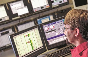
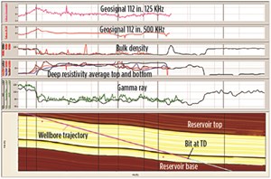
3D data visualization technology. Central to the drilling solution was the StrataSteer 3D dynamic wellbore positioning service, which is designed specifically for smaller targets that require complex well paths and more accurate wellbore positioning and landing Fig. 2. The service integrates digital 3D earth models, planned well trajectories, petrophysical input and real-time LWD data into a flexible visual environment that enables the rapid interpretation required to make critical real-time decisions regarding borehole trajectory changes. The service provides operators with greater reservoir insight to help reduce both planning cycle-time and drilling hours, while enhancing reservoir understanding for maximum contact.

WELL EXECUTION
During drilling operations, data captured from the sensors was processed through the forward modeling functionality of the StrataSteer 3D earth model software, to predict the top entry point in the reservoir. The project was hampered by the lack of log correlation between offset wells, which caused uncertainty in geological scenarios. However, by filtering existing information with new real-time data, it enabled engineers to correlate this information with select offset wells leading to understanding of the geological scenarios, enabling accurate wellbore positioning, relative to the reservoir.
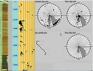
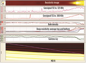
When landing the section, the ABG sensor provided near-bit azimuthal gamma ray readings, showing changes in lithology immediately and ensuring proactive geosteering to avoid unnecessary borehole tortuosity. The ALD delivered dip angles and structural data, which were incorporated into the StrataSteer 3D earth model, Fig. 3. The real-time projection of the reservoir top provided excellent control throughout the landing process. The ADR readings confirmed the presence of hydrocarbons for the wellbore landing, Fig. 4.
Drilling continued in the lateral section, utilizing the same tools, but with different objectives. Because of higher resistivity within the reservoir, the ADR sensor was best-suited to provide sufficient warning for the surrounding formation boundaries. The ABG and ALD data provided the near-bit formation and structural information respectively that complemented the geological model in StrataSteer 3D software. This engineered drilling solution kept the wellbore in the sweet spot, enabling the operator to fully exploit the pay-zone for increased production.
MAXIMIZING ASSET VALUE
The team collaborated with the operator to identify the reservoir challenges and engineer a geosteering solution to maximize the value of the deepwater asset. The solution-based design(s) included a thorough analysis of offset data, along with forward modeling of various down-hole sensor technologies. After the study, the engineering team determined an integrated MWD/LWD/RSS combination had the potential to efficiently achieve the operator’s two main drilling objectives—increase production and lower costs.
Operational success. During the run, at-bit ABG readings showed variations in geology, enabling accurate and quick detection of the formation top, optimizing the entry point and enabling the drilling team to successfully land the wellbore in the target zone. The model was updated continuously to accurately determine formation dip and lithology, increasing drilling efficiency through enhanced reservoir understanding. The geosteering solutions enabled the drilling team to keep the lateral in the target pay-zone 100% of the time, stopping above the oil water contact, Fig. 5. In addition to increasing production, the engineered geosteering solution saved the operator approximately $600,000, aiding in maximizing the value of this deepwater asset. ![]()

- Advancing offshore decarbonization through electrification of FPSOs (March 2024)
- Subsea technology- Corrosion monitoring: From failure to success (February 2024)
- Driving MPD adoption with performance-enhancing technologies (January 2024)
- Digital transformation: A breakthrough year for digitalization in the offshore sector (January 2024)
- Offshore technology: Platform design: Is the next generation of offshore platforms changing offshore energy? (December 2023)
- 2024: A policy crossroads for American offshore energy (December 2023)


