Newfoundland and Labrador excel as center for oil-and-gas-related Arctic R&D
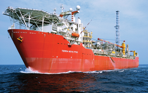
As regards various oil and gas provinces worldwide, the Canadian province of Newfoundland and Labrador (NL) is a special place. It has enjoyed an unbroken string of four major offshore development projects (Fig. 1), dating back to the first field, Hibernia, for which exploitation began in earnest in the early 1990s. And even as the global upstream industry suffers through its worst downturn since the mid-1980s, a solid level of activity continues offshore NL and in St. John’s, the provincial capital, thanks to the long-term nature of the area’s projects.
In the process of developing the significant oil and gas resources offshore NL, operators and their service/supply partners have had to contend with a host of harsh environment issues. In solving these challenges, the NL offshore industry has built up an impressive amount of technical expertise, including Arctic-style conditions (even though the province is not in the actual Arctic).
Accordingly, through government initiatives directly, partnerships with the industry, and university research centers, the province is building up an impressive resume of non-profit R&D capabilities. What follows is a sampling of some of the major R&D efforts being conducted in NL, particularly in St. John’s.
C-CORE
Established in 1975, C-CORE is a Canadian ISO 9001-registered R&D organization that is headquartered in St. John’s, the NL capital. With its harsh-environment expertise and world-class technical capability in Remote Sensing, Ice Engineering and Geotechnical Engineering, C-CORE provides research-based advisory services and technology solutions.
These capabilities help oil and gas clients, and others, mitigate operational risk in harsh environments and address security, sustainability and safety issues related to their regulatory and operating needs worldwide. C-CORE is home to the Centre for Arctic Resource Development (CARD), an industry-guided initiative that pursues medium-to-long term R&D dedicated to responsible, cost-effective development of hydrocarbons in high latitudes. C-CORE also is home to LOOKNorth, a Canadian national Centre of Excellence for Commercialization and Research, dedicated to remote sensing innovation in support of remote resource development.
Over the last 41 years, C-CORE has worked on every continent, in most oceans and in outer space. (The organization designed and built components for Space Shuttle, Foton and Soyuz missions, and the calibration transponders controlling the European Space Agency’s newest satellite, Sentinel-1.)
C-CORE completes 100+ applied R&D and science-based consulting contracts each year, solving specific problems for clients in the resource development, energy, transportation and security industries worldwide. It should be noted that the organization is a not-for-profit; if it develops good, useable technology, C-CORE spins it out. Over the years, 18 companies have been spun out of C-CORE’s R&D.
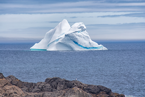
Smart Ice Management System/Rapid Iceberg Profiling System. Given the climatic conditions of oil and gas development offshore Newfoundland and Labrador (NL), ice management is a necessary, priority item for operations. Accordingly, high-quality iceberg profile data are an essential element of an intelligent ice management toolkit.
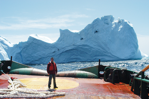
C-CORE has developed a high-resolution, rapid iceberg profiling system that uses a hull-mounted multi-beam SONAR for the iceberg keel (the portion below the waterline) and a deck-mounted LIDAR for the iceberg sail (the portion above the waterline). A field program (Fig. 2) was undertaken during the spring and summer of 2015, to collect 10 different iceberg profiles found in the waters off eastern Newfoundland, ranging in size from 20 m to 190 m (waterline length).
Profiling was demonstrated at a speed of up to 6 kts, allowing a 100-m (waterline) iceberg to be profiled in under 5 min. The system is able to collect data, even when significant vessel roll/pitch is evident, and is able to compensate for iceberg movement during the profiling interval.
Having an accurate iceberg profile enables more accurate prediction of drift direction, break-up and melt. It also facilitates safer, more efficient iceberg towing operations by ensuring optimal placement of towing ropes/nets and selection of the optimal number of towing vessels, etc.
FISHERIES AND MARINE INSTITUTE
As a campus of Memorial University of Newfoundland, the Fisheries and Marine Institute (MI) is Canada’s most comprehensive center for education, training, applied research and industrial support for the ocean industries. Situated on the edge of the Atlantic Ocean, MI is a respected center of marine learning and applied research.
The Marine Institute provides more than 20 industry-driven programs, ranging from technical certificates to master’s degrees. In addition to undergraduate and graduate degrees, MI offers advanced diplomas, diplomas of technology, and technical certificates.
The institute also runs a variety of short courses and industrial response programs, including offshore petroleum industry training and maritime transportation training. All programs and courses are designed to provide students with knowledge and skills required for success in the workforce.
The Institute has three Schools—the School of Fisheries, the School of Maritime Studies and the School of Ocean Technology—and within these schools a number of specialized centers and units, including the Centre for Marine Simulation. These centers and units lead the institute, both nationally and internationally, in applied research (MI operates two vessels that are available for research studies and testing) and technology transfer, and in the provision of training to a variety of industry clients.
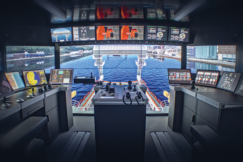
Centre for Marine Simulation. In operation since 1994, and headquartered in St. John’s, the Centre for Marine Simulation (CMS) is a key industrial arm of MI. Operating under MI’s School of Maritime Studies, CMS combines its unique North Atlantic location, world-class simulation technology, and industry-driven expertise to solve the toughest simulation problems for its clients.
As a center of excellence, CMS responds to a variety of requests. The Centre is focused on providing leading-edge marine simulation services to the shipping and offshore industries, which are challenged with difficult and harsh operating environments. The Centre combines technology, operational expertise, and strong innovation to work with its clients in ensuring that operations are carried out safely and efficiently. With its location in St. John’s, on the frontier of oil and gas operations occurring in waters famous for bad weather and ice, the center has uniquely grown its technical ability to adopt and integrate technology that is being developed by companies, locally and globally, to help in efficient offshore exploration and development.
Among its higher-visibility projects, CMS is mid-way through a multi-million-dollar JIP that is developing next generation Dynamic Positioning (DP) software, which could be used in station-keeping efforts for exploratory drilling in ice-covered waters. Project aims include the development of more advanced visual and numerical ice modeling, which will be used to enhance DP simulation exercises of ships maneuvering and operating in various ice conditions.
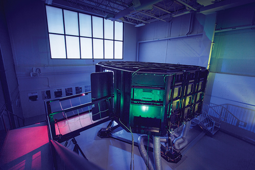
In addition, CMS recently added a new offshore operations simulator (Fig. 3). It simulates offshore support and anchor-handling vessels on a 6o of freedom motion basis, which will be used by offshore operators to carry out training, not only for activities such as rig support and mooring operations, but also, uniquely, iceberg towing operations.
CMS also develops ship models and geographic databases that provide high-fidelity representations of its clients’ actual ships and operational areas, respectively. Ship models can range from FPSOs to icebreakers, shuttle tankers and container ships. As part of its industrial response capacity, CMS carries out projects for companies looking at port design and evaluation, ship performance evaluation, and assessment of risk and other factors on personnel in highly complex or stressful situations.
In keeping with its harsh environment theme, CMS is a leading provider of ice navigation training services. It has prepared people from companies, navies, and coast guards to undertake voyages in ice-covered waters. CMS also can provide services to land-based engineering companies, using its expertise, technology and motion-capable infrastructure.
ARCTIC OPPORTUNITIES INITIATIVE
The Arctic Opportunities Initiative (AOI) is a provincial initiative to promote economic development in Newfoundland and Labrador (NL) by exploring areas of Arctic-related opportunities, building knowledge and capacity; creating international awareness about the province’s abundant Arctic capabilities and expertise, as well as facilitating partnerships among stakeholders and with other northern jurisdictions.
Through the AOI, officials have been positioning the province as the “Path to the Arctic,” as well as an ideal staging ground for Arctic-related activities. The province believes that it is well-positioned as a landmark location for Arctic opportunities, as a result of the following advantages:
- A strategic location on international shipping lanes and northern sea routes
- Home to Arctic communities and aboriginal peoples with traditional knowledge and unique experience
- Transportation and logistical expertise in remote locations, and in Arctic-like conditions
- Experience with safe and sustainable development of natural resources in cold, harsh and ice-infested environments
- A diverse and environmentally sustainable northern mining sector
- Industrial infrastructure to support a growing energy sector, including accessible ports with year-round capacities
- A mature service-and-supply sector with ice-classed vessels
- A world-renowned ocean technology cluster and R&D facilities
- Home to a national center of excellence for Arctic research and development in cold ocean technologies and harsh environment operations
- Superior ice surveillance and management expertise, Fig. 4.
- An industry leader in remote satellite monitoring and communications
- A leading provider of academic and skills development programs, and remote northern education.
Further to the AOI’s mission, the waters offshore Newfoundland and Labrador, surrounded by the North Atlantic Ocean, are colder than anywhere else in the world south of 60o—even colder than those waters near Norway and in parts of Alaska, Greenland and Iceland. While not technically “in the Arctic,” the conditions are absolutely Arctic in nature, resulting in some of the world’s most innovative and reliable solutions to cold-ocean challenges. This is all done while offering the amenities of a modern, world-class location.
Through the AOI, a memorandum of understanding (MOU) was signed between NL and its sister territory of Nunavut on July 16th, 2015. The MOU is intended to promote responsible economic development, and enable stakeholders in both jurisdictions to mutually benefit from opportunities emerging in the Arctic. NL and Nunavut share many connections. These connections have encouraged an increased exchange of knowledge and greater collaboration between the two jurisdictions. Under the recently signed MOU, areas identified for collaboration include natural resources, education and training, transportation and infrastructure, culture and tourism, research and development, and health care, Fig. 5. Some basic knowledge of the tenets of the Path to the Arctic is available on this website: http://thearcticpath.com/.
PRNL
Petroleum Research Newfoundland and Labrador (PRNL) is a federally-incorporated, not-for-profit organization. It facilitates research and technology development, and strives to deliver value to members by identifying opportunities, developing proposals, and funding and managing the execution of projects on behalf of the NL offshore oil and gas industry.
PRNL is a member-based organization that seeks proposals for research and technology development projects that address the operational, technical and business needs of its members. The organization issues Requests for Proposals (RFPs) that focus on specific member needs. In addition, PRNL issues an annual “Call for Proposals,” which addresses one of the group’s strategic focus areas and provides an opportunity for proponents to submit a scope of work. PRNL also accepts unsolicited proposals from individuals or organizations conducting research in a particular subject area or field that is of potential interest to its members.
Environmental genomics. One of the industry projects that PRNL is supporting at the moment is “environmental genomics.” Environmental genomics is defined as “the study of genes to characterize biological components of the environment.” The application of genomics has the potential, say officials at the organization, to augment conventional approaches to environmental assessment and monitoring, providing cost-effective, robust and potentially comprehensive biodiversity information to support project operations. PRNL and eDNAtec are working on the construction of a genomics research center in NL. Once built, the center will be equipped and ready to significantly advance the research necessary to effectively apply environmental genomics in environmental assessment and monitoring, including for upstream oil and gas purposes.
In June 2016, an International Workshop on Environmental Genomics: Understanding the State of Science and Research Opportunities, was held in St. John’s, NL. This workshop included the participation of leading experts in environmental genomics from academic and governmental institutions, as well as international oil and gas companies, from Canada, the U.S., Europe, South America, Asia and Australia. The workshop examined the state of the science of environmental genomics, to identify research opportunities that could help advance mainstream applications of the technology in environmental characterization and monitoring efforts. The workshop also resulted in the formation of a consortium/working group of leading genomics researchers and industry, which will work toward the advancement of environmental genomics research.
With the research that is expected to be undertaken in the environmental genomics center, combined with the ongoing international genomics activities being hosted by NL, the province feels that it will be uniquely positioned to become an international hub for the development of new methodologies. These methodologies would apply environmental genomics in environmental assessment, with an emphasis on those applications most relevant to oil and gas operations. The outcomes of the research will benefit all stakeholders from public and private domains that depend on biodiversity/environmental data for decision-making.
RESEARCH & DEVELOPMENT CORPORATION OF NEWFOUNDLAND AND LABRADOR
The province of Newfoundland and Labrador, through its Research & Development Corporation (RDC), has invested significantly in Arctic and Harsh Environment R&D projects. Since 2009, RDC has supported 123 projects in this field, with a combined value of more than $33 million, or one-quarter of RDC’s total investments in R&D, to date. RDC’s investment in this area has leveraged $89 million from industry, the Canadian federal government and other sources. What follows are some examples of projects in which RDC has invested.
Intelligent winch systems for Arctic conditions. Rolls-Royce Canada Limited’s Mount Pearl-based facility will address the challenges of loading and unloading supplies to and from offshore oil and gas platforms/rigs (fixed or floating) during inclement sea states, Fig. 6. The company plans to develop an intelligent winch system that will be designed to increase operational availability of cargo transfer between offshore supply vessels, and oil and gas platforms.
Offshore supply vessels often operate in harsh environments, and this new system will significantly increase the safety of personnel working on those vessels. This proposed winch system will automatically compensate for the relative motion between the two bodies (vessel and platform) prior to the connection between the load and the cargo lifting hook. RDC’s investment is $300,000, out of a total project cost of $951,950.
Development of an offshore evacuation system for operations in ice-covered regions. Aker Arctic Canada Inc. (AKAC) will team with multiple industry partners and the National Research Council to conduct scale-model testing of a totally enclosed, ice-strengthened lifeboat (ISL).
There are some limitations to a totally enclosed, motor-propelled survival craft (TEMPSC) in ice-covered regions, which pose both a safety concern and an operational challenge to the offshore industry locally, nationally and internationally. Previous research has shown that typical offshore evacuation crafts have limited capabilities to safely transit away from an offshore installation in ice-covered conditions. An Escape-Evacuation-Rescue system that can provide the ability to safely evacuate people under those conditions would have strong commercial applicability, not only to the offshore industry, but also to other industries.
Through a previous PRNL Joint Industry Project (JIP), AKAC teamed up with various industry partners to develop the ISL, which is a TEMPSC (totally enclosed motor propelled survival craft) concept that is designed specifically to operate both in open water and ice-covered waters. This project’s objective is to assess the operability of the ISL concept in a range of ice conditions through model testing. RDC’s investment is $309,166, out of a total project cost of $618,333.
SULIS 1i: 3D subsea inspection tool. Underwater assets, such as risers, pipelines and moorings, must be inspected regularly to ensure integrity and assess any damage. Similarly, marine archeological discoveries, such as shipwrecks or lost artifacts, must be inspected closely, to verify authenticity and discover new knowledge.
SULIS Subsea Corporation (SULIS) plans to develop new 3D imaging technology to aid in these activities, targeting applications in the offshore and marine archeology industries. The company will build on its core imaging technology to develop an inspection system capable of producing high-fidelity 3D models. The technology aims to provide the information needed to make informed decisions, and help ensure safe offshore operations. RDC’s investment is $180,500, out of a total project cost of $611,827. Additional information on RDC projects is available at http://www.rdc.org/discover/project-database/. ![]()