|
The world is awash these days with news of drones. Some of that news focuses on drones (or unmanned aerial vehicles [UAV]) used by the military, either to good cause or with fatal, unintended consequences. Much of the news deals with the use of drones for non-military surveillance, with considerable grinding of teeth about the potential of unmanned surveillance craft to compromise, or eliminate, our personal privacy. The discussion will only get more heated, as thousands of drones overfly almost every square mile of earthly terrain in the coming years.
 |
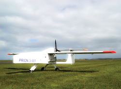
| TGS Geophysical winged drone. |
|
Some of those drones flying overhead will not be spying on you but on the geology under your feet. Drone-deployed geophysical equipment is already being deployed in several places in the world. The benefits are obvious. Drones are smaller, less capital-intensive (standard models can average about $16,000, each), cheaper to operate and, being unmanned, pose no danger to a pilot and crew. In addition, the UAV setups have higher resolution and accuracy compared to manned aircraft, due to the fact that the UAV can fly with much smaller ground clearance. They also can fly over only the area of interest.
While drones may be some way off from acquiring actual full seismic data, they can deploy magnetic, electromagnetic, infrared, radar and natural gamma ray sensors. These tools, along with surface examination of exposed formations and electromagnetic surveys, are yielding results from the North Sea to Australia.
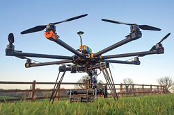
In the North Sea, researchers from the University of Aberdeen in Scotland, and the University of Bergen in Norway, are extrapolating subsea formations from exposed cliff face formations. Using eight-rotor drones (octocopters) fitted with cameras, the project, called SAFARI, generates 3D models of the cliff faces to help identify potential reservoir and seal rocks.
On the other side of the world, Australian company Shift Geophysics is studying the viability of drone-deployed electromagnetic surveys, following on their use of airships (blimps) for the same work. A recent study, presented by Shift’s Adam Kroll at the 23rd International Geophysical Conference and Exhibition, Aug. 11–13, 2013, raises as many questions as it answers.
According to the Shift study, “data quality can be affected, either positively or negatively, depending on the type of UAV used for the type of geophysical acquisition. Magnetic data is negatively affected by permanent, induced eddy current fields, high-frequency electromagnetic noise and microphone noise generated from the airborne platform.” And, data quality will be significantly impacted by the type of sensor used. Fluxgate magnetometers, preferred due to payload size and weight restrictions, are more susceptible to attitude changes than cesium vapour magnetometers.
An unmanned vehicle of any sort improves safety by eliminating an onboard operator/pilot. As Kroll notes, “The International Airborne Geophysics Society Association’s (IAGSA) published statistics have attributed 1.75 fatalities per 100,000 flight hr, due to airborne geophysics operations.” With no personnel on board, that figure falls to zero. And, the UAV can fly for a much longer period of time without limitations about how long an onboard pilot may fly without relief.
Without personnel on board, however, the UAV is still an airborne missile capable of inflicting damage and/or death, should it fall from the sky. Therefore, operators should be diligent in determining that the UAV is well-maintained and has the requisite, and redundant, equipment to maintain course and altitude.
 |
| Versadrones Heavylift octocopter capable of carrying up to 4 kg payload. Photo credit: HexCam Aerial Photography. |
|
Drones are relatively new and not well-incorporated with differing aviation regulations of various countries. Western countries have generally put into place basic regulations for UAV operations, although most of the regulations are relatively recent. The U.S. Federal Aviation Administration, for example, issued approval for ConocoPhillips to fly unmanned drones in U.S. airspace last July. ConocoPhillips will use the drones for emergency response, oil spill monitoring and wildlife surveillance.
There is little doubt that the demand for drone-deployed geophysical surveying will grow. Its growth, says Kroll, will depend, to some extent, on potential operators understanding a set of limitations:
- Several terrains are not ideally suitable for certain UAV activities, such as operations near oceans.
- UAVs are not as reliable as manned aircraft, requiring rigorous planning, maintenance and best-practice safety systems.
- Regulations in many countries do not allow UAV flights, or require the operator to ensure that the crew has certain qualifications.
Regardless of the arguments against UAV geophysical acquisition, the trend will build. It’s just too cost-effective and too efficient. 
|


