What's happening in exploration
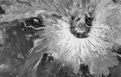
Satellite seismic; free aerial photosFor years, the seismic industry has been developing ways to improve the acquisition-to-processing cycle. Some service companies have recently begun transmitting, in real time, QA/QC data and limited video to allow client interaction in the acquisition process. However, raw seismic data generally contains too much data to transmit to the client. One way around this dilemma is to transmit stacked sections – which are less data intensive – but these require processing in the field. If there’s a fiber optic cable nearby (such as Petrocom’s SONET ring in the GOM), it can be used to transmit these large data volumes. One solution – commercial satellite transmission of raw seismic data – has been experimented with, achieving transfer rates of about 25 Mbps. However, it turns out that NASA has an outstanding satellite network called TDRS, comprising six, high-bandwidth satellites in geo-synchronous orbits worldwide and an array of 16-ft tracking antennae in White Sands, New Mexico. NASA has recently had to deal with budget cutbacks and has been directed to commercialize some of its space communications operations – a fortunate event for the seismic industry. Through complex arrangements with NASA and General Dynamics Worldwide Telecommunications Systems (GDWTS), SpaceData International LLC has created the SeismicStar program. It’s the world’s fastest commercial satellite transmission system. The new service will focus on the marine seismic market. It is designed to transmit data at 311 Mbps from the vessel to a network of terrestrial receivers via satellite, and then – through fiber optic networks – to supercomputers for processing. As a point of reference, a 10-streamer, dual-source seismic vessel with 240 channels per cable will generate roughly 165 GB per day. Thus, an entire day’s recording can be transmitted in about an hour. Transmission speeds should increase to 466 Mbps in the near future. GDWTS will assemble, integrate, test, install and remotely operate SeismicStar terminals on seismic vessels and transfer the data daily. A typical onboard SeismicStar terminal setup comprises a 2.4-m, SeaTel-designed marine-tracking antenna and radome assembly, 1 TB of RAID storage with StorageTek’s 9145 for data cache and dual Sun E450 servers operating Solaris 2.6. This service will clearly allow faster turnaround times than the current method of physically transferring data tapes to land by helicopter. Some of the major geophysical contractors are considering its use. Further information can be obtained from Jay Gnowles at jgnowles@spacedata-int.com. Free aerial photos. This was just too neat not to mention. In our business, we all have to work with many types of maps – often daily. While surfing one evening, a new website caught this editor’s eye. At http://terraserver.microsoft.com, you will find the USGS atlas of the U.S. and selected portions of Europe and Asia, in photos and topo maps, down to 1-m resolution. The JPEG versions are free. Although the picture shown here of Mt. St. Helens is visually striking, seeing one’s home on the Internet – albeit from the air – somehow seems more interesting. Try it.
Egyptian gas soars. The Repsol / Apache / Novus consortium struck again with its Shams-8X well on its Khalda concession. The well perforated 42 ft of pay at 13,168 ft. It tested 25.3 MMcfgd and 139 bcpd through a 1.0-in. choke with 1,330-psi FTP. The well extends Shams field by one-third, to 3,000, acres and should add at least 50 Bcfg in reserves, bringing the total to 428 Bcfg and 6.3 million bbl of condensate. Shams-8X is the second exploration well drilled on the Khalda Ridge Jurassic gas trend. The concession currently produces about 137 MMcfgd and 50,000 bcpd. Apache’s Egyptian concessions comprise 26.3 million acres, an area roughly the size of Pennsylvania; this was its fourth Egyptian discovery in 2000. In February, the Apache / Repsol partnership announced a discovery on its three-million-acre West Mediterranean concession. The Akik-1X tested 23.4 MMcfgd and 1,685 bcpd on a 48/64-in. choke with 2,274-psi FTP. Forty-eight ft of pay was perforated at 8,112 ft, and the company was last reported drilling ahead to test deeper zones. The same partnership drilled the Karama-1X on its 1.4-million-acre East Bahariya concession. An 18-ft interval was perforated at 7,552 ft; it tested 1,520 bbl of 43° API crude and 500 Mcfgd. Apache and partners plan to drill at least 10 more exploration and delineation wells in Egypt this year. A major reason for the Egyptian gas activity is due to contract terms with foreign operators. A gas clause, introduced in the late 1980s and amended in the early 1990s, tied gas prices to crude prices. That clause has spectacularly achieved its objectives of spurring gas exploration, as proved gas reserves have soared from 12 Tcf in 1992 to 40 Tcf today. The contract terms mean that, at $30/bbl Brent, Egypt will
pay $3.60/Mcfg. Egyptian supply will likely exceed demand within a year. The recent
agreement between EGPC and UK’s BG will supply another 530 MMcfgd, beginning in 2003,
from the West Delta Deep Marine offshore concession, Egypt’s largest gas development
project. Just how the government will pay for this gas and where it will all go is anyone’s
guess.
|