EXPLORATION REPORT
Regional geology of deepwater salt architecture: New plays in the GOM
Clarity beneath the salt is essential to understanding the Lower Tertiary. The trend could continue further to the east.
Abu Chowdhury and Laura Borton, TGS-NOPEC Geophysical Co., Houston
In deepwater Gulf of Mexico, the new Lower Tertiary play shows great promise�as much as 15 billion bbl of potentially recoverable reserves, according to the MMS. There has been a rash of discoveries in recent years, including the much publicized Jack-2 and Kaskida fields in the Lower Tertiary formations, which is sometimes referred to as the Wilcox trend, and has long been recognized as a major petroleum resource throughout the Texas and southwestern Louisiana area. Discovery well depths have been as shallow as 15,000 ft in some areas to as deep as 30,000 ft in others.
Significant work has been done in unraveling the deepwater geology and salt tectonics of the Gulf of Mexico. A number of authors have recognized the presence of allochthonous and autochthonous Louann salt bodies in Gulf of Mexico. The mechanism of salt evacuation in relation to sediment loading and forming into various salt archetypes (fore-ramp rooted, back-ramp rooted, sutured, salt tongues and canopies) has been discussed. The implications of using various salt shapes to locate hydrocarbons have also been published.
Most of these works were based on well logs and time-migrated seismic data. Depth-migrated seismic data provides a much better image of salt complexes and subsalt geology because of better velocity modeling for processing the data. Good imaging of folded structure below the salt helps delineate the new Lower Tertiary play, which can possibly be tested in Mississippi Canyon.
This study is based on two regional pre-stack depth-migration projects that were recently undertaken to better image the deepwater salt and sub-salt geology. The autochthonous Jurassic Louann salt, Jurassic sediments and the overlying Cretaceous and Paleogene sequences are well manifested in the data sets.
BACKGROUND
The new Lower Tertiary play is typically characterized by broad rollover structures created by sediment loading, deflation and withdrawal of the mother salt, and subsequent sediment collapse.
Salt and sediment interactions play a major role in producing reservoir rocks and traps for hydrocarbon accumulation in the Gulf of Mexico. Pre-Stack Depth Migration (PSDM) and recently drilled deepwater wells have provided better understanding of salt geology and new hydrocarbon plays.
THE DATA
The two seismic pre-stack depth-migrated data sets were used to delineate the deepwater salt and associated geology, Fig. 1. Phase 45 Too (P-45), a regional 2D project, integrated about 1,100 wells, including 300 biostratigraphic wells, in the interpretation of salt and regional geology. The dataset stretches from Corpus Christi/Port Isabel in the west to Atwater Valley in the east and comprises about 100,000 line-km of 2D seismic data. The data record length is 13�14 sec. and 80�106 fold and was shot with a 6- to 8-km streamer.
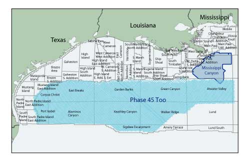 |
Fig. 1. Study areas showing the seismic grid.
|
|
The other project, Mississippi Canyon, a large 3D PSDM dataset, comprises about 900 OCS blocks (each 4.8 km x 4.8 km) and was also pre-stack depth migrated. More than 80 salt penetration wells were integrated to enhance the velocity model in the Mississippi Canyon salt model. The data record length is 12.3 sec. and 64 fold and was shot with an 8-km streamers. The interpreted data identified autochthonous and allochthonous salt and associated archetypes.
METHODOLOGY
In both the P-45 and Mississippi Canyon projects, the top and base of salt were mapped during the PSDM using this workflow:
1. Sediment velocity model is created by converting PSTM velocities to depth and removing salt velocities.
2. Pre-processed gathers are migrated with the sediment velocity model.
3. Top of salt is interpreted based on its seismic signature of high-amplitude, low-frequency reflections and diagnostic reflection geometries.
4. Salt-flood velocity model is created by overlaying the top-of-salt interpretation on the sediment velocity model and flooding the volume below the top of salt with salt velocity.
5. Pre-processed gathers are migrated with salt-flood velocity model.
6. Base of salt is interpreted.
7. Final velocity model is created by overlaying the top- and base-of-salt interpretations on the sediment velocity model and filling the body with salt velocity.
8. Perform final migration.
9. Perform post-processing.
To aid in picking top and base of salt, water bottom and top-of-salt multiples were calculated and mapped to discriminate primary salt reflections from multiple reflections. In addition, depth gathers were analyzed for flatness as a quality control.
In P-45, eight sequence boundaries from the Lower Pliocene down to the Cretaceous were also mapped to decipher the geology. The sequence boundaries were picked based on the integrated interpretation of biostratigraphic data, well log stacking patterns and seismic reflection patterns.
REGIONAL GEOLOGY OF DEEPWATER SALT
The salt in deepwater GOM varies in size and structural style compared to the shelf/slope salt.
Salt description. The allochthonous salt in the shelf/slope ranges from diapiric bodies to regional Roho salt structures (deformed salt canopies created as a result of vertical and lateral movement due to sediment loading and density variation) to thin welds. Many of these salt features are associated with a regional decollement surface that can be traced downdip into deep waters. The thickness of most of these salt structures varies from 0.2 km to 3 km, and the ratio of salt to sediment is approximately 30:70. The autochthonous root is rarely visible on the shelf.
In contrast, deepwater salt bodies are massive; they attain thicknesses up to 6 km in Alaminos Canyon, Keathley Canyon, and southern Garden Banks. They generally have gently dipping bases, unlike the salt bodies of eastern Walker Ridge and southeastern Green Canyon, which show steep dips. The salt further east in Atwater Valley generally dips gently. The salt body architecture commonly varies from back-ramp rooted to deflated autochthons or allochthons.
Some salt bodies in Mississippi Canyon (Thunder Horse area) appear to be rooted and show thicknesses up to 8 km. The salt-sediment ratio in the deepwater GOM is approximately 60:40.
Regional structure. The key regional structural elements, namely, the Perdido fold belt, Sigsbee salt canopy and Atwater/Mississippi fold belt, are directly associated with salt tectonics. The northeast trending Perdido fold belt extends from the southern GOM into Alaminos Canyon. The folded sediments are composed of Upper Jurassic to Eocene rocks underlain by high-relief autochthonous Louann salt. The fold belt was possibly formed during the Cretaceous-Eocene time associated with the Laramide orogeny. Cretaceous-Eocene depocenters were present in this vicinity, as suggested by some authors.
The Wilcox sands, deposited between the Upper Paleocene and the Lower Eocene, establish the reservoir for the Lower Tertiary play. The fold belt terminates in Garden Banks, where Plio-Pleistocene, thick depocenters dominate.
The east-northeast trending Mississippi/Atwater fold belt lies in and around the Atwater Valley protraction area and is composed of folded Upper Jurassic to Miocene sediments. Like the Perdido fold belt, the rocks are underlain by Louann salt. However, it differs from the Perdido fold belt in that the reservoir rocks tested by most wells are Miocene in age.
Overlaying these fold belts is the large southward-moving Sigsbee salt sheet. This allochthonous canopy makes seismic imaging a challenge and drilling difficult.
NEW DEEPWATER PLAYS
Exploration in the Gulf of Mexico has advanced from amplitude plays in the shelf/slope environment to salt flank/mini-basin plays on the slope, and now to the new deepwater Lower Tertiary plays. The pre-stack depth migrated dip line in Fig. 2 gives an example of the latter two plays.
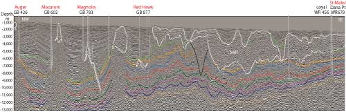 |
Fig. 2. Dip line across Garden Banks and Walker Ridge.
|
|
The sequences from the Pliocene (SA) (about 7 million years old) to the Mesozoic/Cretaceous (MZ) (about 70 million years) are annotated on the section. Starting on the slope at Garden Banks on the left hand side of the section, four successful mini-basin discoveries (Auger, Macaroni, Magnolia, and Red Hawk) and their associated block locations are shown. Continuing across the salt into deeper water in Walker Ridge, St. Malo shows the new frontier deepwater Lower Tertiary play.
The varying salt geometries in the GOM, discussed in the previous section, can also be seen in this figure. The slope is primarily sediment with three allochthonous diapirs, ranging from 0.8 km to 3 km. As discussed, the autochthonous roots are hardly visible. In deep water, the section contains a large amount of salt, up to 6 km thick.
Figure 3 is a pre-stack depth migrated strike line across Walker Ridge and Atwater Valley that again shows the Lower Tertiary play and a Lower Miocene discovery.
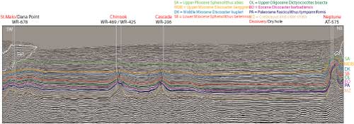 |
Fig. 3. Strike line across Walker Ridge and Atwater Valley.
|
|
The sequences are the same as Fig. 2. Starting in Walker Ridge on the left-hand side of the section, St. Malo is displayed. Crossing the Sigsbee escarpment, Chinook and Cascade, two successful Lower Tertiary prospects, are shown. Arriving in Atwater Valley, Neptune in the Atwater/Mississippi fold belt exhibits a Lower Miocene success.
The recent discoveries, Jack-2 in Walker Ridge and Kaskida in Keathley Canyon, have proven the Lower Tertiary play to be continuous across the deepwater Gulf of Mexico from Alaminos Canyon in the west (e.g., Trident and Great White) to Walker Ridge in the east (e.g., Cascade and St. Malo). The pre-stack depth-migrated seismic section in Fig. 4 shows the Jack prospect. The discovery well (Jack-1) and test well (Jack-2) are noted, and the gamma ray and resistivity curves for Jack-1 are displayed. The frontier play between the Paleocene (PA) and Eocene (EO) geologic horizons is highlighted.
The four Lower Tertiary wells discussed in this article, St. Malo, Cascade, Chinook and Jack (Figs. 2, 3 and 4), have each found significant amounts of oil. The reservoirs are the Wilcox sands in the Paleocene (PA) that are sandwiched between the Mesozoic/Cretaceous (MZ) and the Eocene (EO) sequences, and the closures are associated with salt-cored anticlines. Of special interest are the St. Malo well (Figs. 2 and 3) and the Jack well (Fig. 4), which penetrate about 3 km and 4 km of salt, respectively, before encountering Lower Tertiary discoveries and reaching their total depths at the top of the Mesozoic.
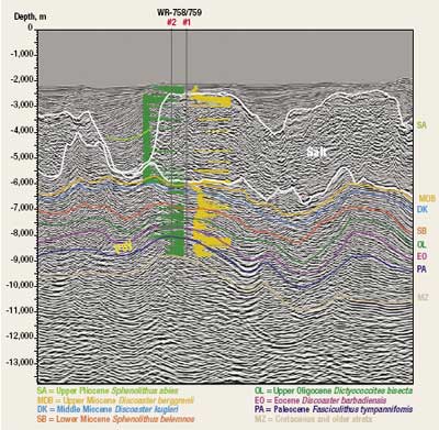
Although most literature has the eastern Lower Tertiary discovery boundary around Walker Ridge, data from Mississippi Canyon suggests that it may extend further east, Fig. 5.
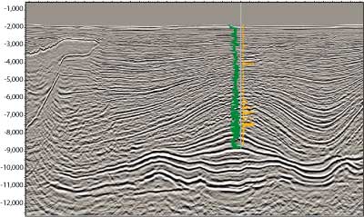 |
Fig. 5. Well drilled in Thunder Horse area of Mississippi Canyon. Is there an extension of the Lower Tertiary below TD?
|
|
This pre-stack depth-migrated section shows the area around the Thunder Horse prospect and the BP well drilled to the Lower Miocene/Upper Oligocene. A rollover structure below the TD of the well is shown, and it is possible that the Lower Tertiary play that has been tested and proven to the west exists here.
CONCLUSIONS
The pre-stack depth-migrated seismic data used in this study clearly images salt geology and the new deepwater plays tested by wells. However, improved imaging of the Lower Tertiary beneath salt is still needed to improve hydrocarbon evaluation. Mississippi Canyon wells that have tested and produced from the Lower Miocene/Upper Oligocene reservoirs may have the potential for Lower Tertiary discoveries as well.
ACKNOWLEDGEMENT
We thank TGS-NOPEC management for their support and permission to publish this article. We also thank Ray Martin, who made significant contributions to the interpretation of the data.
BIBLIOGRAPHY
MMS news release, “Summary of Lower Tertiary play in Gulf,” October 10, 2006.
Feng, J. and R. T. Buffler, “Post mid-Cretaceous depositional history, Gulf of Mexico basin,” A Special Publication of Gulf Coast Association of Geological Societies, Forty-Sixth Annual Convention, p. 9-25. 1996.
Hall, S., “The development of large structures in the deepwater northern Gulf of Mexico,” Houston Geological Society Bulletin, Vol. 43, No. 8, pp. 20-23, 2001.
Hart, W., Subsalt trap archetype classification, “A diagnostic tool for predicting and prioritizing Gulf of Mexico subsalt traps,” GCSSEPM Foundation 21st annual Research Conference, pp. 619-638, 2001.
Mehlhop, A., “Regional salt provinces evaluation aid future exploration,” Offshore, pp. 66-70, January 2004.
Peel, F. J., “The geometry and emplacement history of the major allocthonous salt sheets in central Gulf of Mexico,” A regional view, Geophysical Society of Houston Bulletin (abs.), March 2003.
Meyer, Dave, et al., “Emergence of the Lower Tertiary Wilcox trend in the deepwater Gulf of Mexico,” World Oil, p. 72-77, May 2005.
Trudgill, Bruce D., “The Perdido Fold Belt, Northwestern Deep Gulf of Mexico: Part 1. Structural geometry, evolution and regional implications,” AAPG Bulletin, Vol. 83, pp. 88-113, 1999
Fiduk, Joseph C. et al., “The Perdido Fold Belt, Northwestern deep Gulf of Mexico: Part 2. Stratigraphy and petroleum systems,” AAPG Bulletin, Vol. 83, pp. 578-610, 1999.
|
THE AUTHORS
|
|
Abu Chowdhury manages Interpretation Services at TGS-NOPEC Geophysical Company’s Houston office. He worked as a New Ventures manager and Interpretation manager for Schlumberger/WesternGeco for 11 years. He also worked for SOHIO/BP as a senior exploration geophysicist for over six years. Abu earned an MS degree in geophysics from University of Houston. He has a post-MS diploma in applied geology from Indian Institute of Technology, India, where he was also a post graduate research fellow on the deep sea drilling project (DSDP) of Scripps Institute of Oceanography.
|
|
|
Laura Borton is an interpretation geophysicist with TGS-NOPEC Geophysical Company. Laura joined in 2004 and has 10 years of experience in the seismic industry. She received a BS in physics from the University of Virginia in 1995 and an MS in geophysics from UCLA in 1997. Laura also holds an MBA from the University of Houston.
|
|
|