What's new in exploration
Methane hydrates offshore India; Noteworthy finds
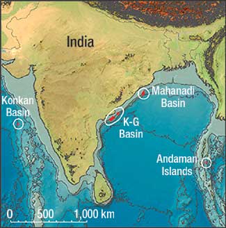
Gas hydrate surprises off India. In mid-August, a team of scientists from India, North America and Europe, led by the Indian Directorate General of Hydrocarbons and the US Geological Survey (USGS), completed a four-month expedition aboard the drillship JOIDES Resolution to explore for gas hydrates offshore India. The science team was led by Dr. Timothy Collett of the USGS, and consisted of more than 100 leading scientists and professionals representing more than 32 scientific and governmental organizations. Based on analysis of geological and geophysical data, the expedition planned to visit 10 sites in four areas (see map). Scientific drilling, well logging, coring and shipboard scientific analyses of recovered samples from each site furthered the objectives, which were focused on the potential of hydrates as a resource. The expedition’s accomplishments included the collection and examination of: over 30,000 ft of sedimentary section at 39 locations, located at 21 sites within the four geologic settings; LWD log data in 12 holes; wireline log data at 13 sites; VSP data at six sites; 494 conventional cores, encompassing 9,350 ft of sediment from 21 holes; detailed shallow geochemical profiles at 13 locations; temperature gradients at 11 locations; and dozens of other scientific assessments. A highlight was the collection of 49 cores (up to 1 m long each) that preserved in situ conditions, leaving virtually undisturbed gas hydrate in host sediments. The expedition was among the most complex and comprehensive methane hydrate field ventures yet conducted. Key scientific highlights of the expedition thus far include:
The initial preliminary technical reports on the expedition’s scientific findings are expected to be released in February 2007. Final technical reports by scientific discipline will be released in January 2008, with final synthesis of the project findings expected later in 2008.
Noteworthy finds. Statoil and partner Total have found an estimated 7 Tcf of gas in Block 4 of the Plataforma Deltana, southeast of Trinidad in Venezuelan waters, as announced by President Hugo Chávez during a televised address. The find was confirmed by drilling a second exploratory well, Cocuina 2-X. The first exploratory well, Ballenas 1-X, was temporarily abandoned in 2005 because of safety concerns. Transocean’s Sovereign Explorer did the drilling. Walter Oil & Gas Corp. made a significant discovery in the Gulf of Mexico in 37 ft of water. The well was drilled to a 14,988-ft MD and penetrated over 300 ft of net pay in Lower Miocene Lentic Jeff sands. The discovery is in High Island Block 24-L in Texas state waters. The results of testing yielded a final flowrate (before shut-in) of 47.5 MMcfd of gas on a 45/64-in. wellhead choke, with 312 bbl of 45.9°API-gravity condensate per day. No information was released on reserves. Given the well’s depth, plus the fact that this block was only bid for and awarded in April 2006, it is a model of successful fast tracking to have concluded farm-ins, and drilled and completed a 15,000-ft discovery by early November. Equally fast, the operator is planning to have the well on production by the end of first-quarter 2007. Oil shale projects approved. As predicted, the US Dept. of the Interior (DOI) completed analysis on five oil shale research, development and demonstration projects on public lands in Colorado’s Piceance basin. The Environmental Assessments for projects proposed by Chevron, EGL Resources and Shell Frontier Oil & Gas have been approved, clearing the way for issuance of 160-acre leases associated with each proposal. The target is the Green River formation, covering portions of Colorado, Utah and Wyoming. More than 70% of the formation, including the richest and thickest oil shale deposits, lies in federal lands. The usual political blather accompanied the announcement, such as how these projects will hasten US energy independence, pointing to a potential 800 billion bbl of recoverable oil and a 110-year supply. That is, assuming these projects go unbelievably well. New database. A part of the US Energy Policy Act of 2005 directs the DOI to establish a national geological and geophysical database. The USGS National Geological and Geophysical Data Preservation Program implementation plan was delivered to Congress and released at http://energy.usgs.gov. The new program will inventory, archive, preserve and catalog geologic, geophysical and engineering data, maps, well logs and samples. The database will contain geological and geophysical information easily accessible through the Internet-based National Digital Catalog, allowing users to quickly identify what is available and where it is located. The program will provide consistent standards, while facilities and collections will be managed by the USGS and maintained by agencies within the DOI and State geological surveys. For more information, contact Tamara Dickinson at: tdickinson@usgs.gov.
|
|||||||||||