01-09_tectonic-mann_fig1.htm (Sep-2001)
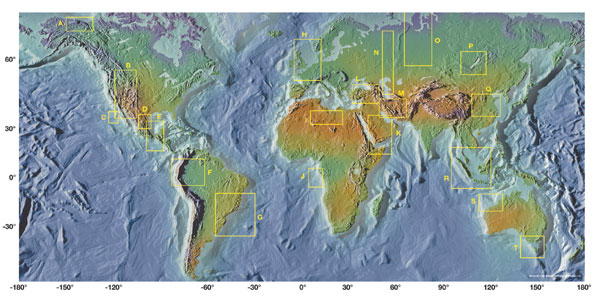
Fig. 1. Global distribution of 592 giant oil fields plotted on topographic-bathymetric world map. Yellow boxes indicate concentrations of giant oil fields shown in detailed figures. A) Alaska; B) Rocky Mountain foreland; C
 |
|
Fig. 1. Global distribution of 592 giant oil fields plotted on topographic-bathymetric world map. Yellow boxes indicate concentrations of giant oil fields shown in detailed figures. A) Alaska; B) Rocky Mountain foreland; C) Southern California; D) Permian and Anadarko basins; E) Gulf of Mexico; F) Northern South America; G) Brazil; H) North Sea; I) North Africa; J) West Africa; K) Arabian Peninsula / Persian Gulf; L) Black Sea; m) Caspian Sea; N) Ural Mountains; O) West Siberia; P) Siberia; Q) China; R) Sunda; S) Australia; T) Bass Strait / Australia / Tasmania. |
- Applying ultra-deep LWD resistivity technology successfully in a SAGD operation (May 2019)
- Adoption of wireless intelligent completions advances (May 2019)
- Majors double down as takeaway crunch eases (April 2019)
- What’s new in well logging and formation evaluation (April 2019)
- Qualification of a 20,000-psi subsea BOP: A collaborative approach (February 2019)
- ConocoPhillips’ Greg Leveille sees rapid trajectory of technical advancement continuing (February 2019)

