What's new in exploration
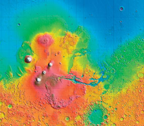
Good discoveries; interesting Martian geologyA wildcat drilled by Ocean Energy struck oil on its East Zeit concession, located offshore Egypt in the Gulf of Suez. The A-21 well was drilled to a 16,300-ft TD and encountered about 745 ft of gross oil pay. Initial production should have begun by November. Ocean holds a 100% working interest in the field. The discovery could add 40 to 80 million gross bbl to the 87 million bbl already produced from the East Zeit field. "This discovery exemplifies the appreciable exploration upside that remains in what is considered a mature province," said John Schiller, executive vice president of operations. Spinnaker Exploration struck gas and condensate again, this time at its Resolute prospect on High Island Block 197, in federal waters 35 mi offshore Texas. The HI 197-1 was drilled to 13,956-ft TD. The well encountered 140 ft (TVD) of hydrocarbon-bearing section in two intervals within the Miocene Robulus sequence. Both intervals are hydrocarbon-filled to the base of the sands. The well has been completed, although no flowrate data was released. Additional drilling is planned for the new field discovery during the fourth quarter of 2001. Spinnaker operates the block and owns a 50% working interest. Its partners are Continental Land & Fur (25%) and Westport Resources (25%). Tharsis marshes. For a unique and interesting experience, try studying Martian geology. The Mars Orbiter Laser Altimeter (MOLA) on the Mars Global Surveyor spacecraft and other data have allowed planetary geologists and other scientists studying the red planet to make some startling hypotheses. A team of nine scientists – drawing on their own work, the MOLA team and other research – reported their basin / aquifer-system hypothesis in the Journal of Geophysical Research – Planets. Lead author of the report is James M. Dohm from the University of Arizona, and it can be read as a pdf file at: http://www.agu.org/pubs/pip/2000JE001468.pdf. Evidence that water once existed on Mars is a virtual certainty. What the 10-year study discovered is an enormous ancient drainage basin and aquifer system that lies hidden and deformed in a geologically dynamic Martian landscape. The basin, called Tharsis, is roughly the size of Europe and for billions of years covered most of a magmatically active bulge. Tharsis landforms are a complex of towering volcanoes, lava flow fields, igneous plateaus, fault and rift systems, flood channels, vast canyon systems and tectonic features (see figure).
Most scientists believe that periodic magmatic flows at Tharsis had a major effect on Mars’ geology, hydrology and climate for more than three billion years. The scientists estimate that the 11-million mi3 basin ranged between 1.2 mi to 4.4 mi deep. Early in Mars’ history, lava and sediment partly infilled the basin, transforming it into an enormous regional aquifer. This water source carved what are probably the largest flood channels in the solar system and helped fill lakes and oceans on ancient northern Mars. Baker, Strom and others have long held a "Mega-outflow" hypothesis, which says that Mars’ northern plains featured oceans at least once in the ancient past. The hypothesis further states that periodic magmatic activity triggered catastrophic floods, formation of oceans or lakes in the northern plains and brief episodes of climate change lasting tens of thousands of years. A 2.2-MB, 3-D QuickTime movie, showing how the Tharsis region evolved, can be downloaded from http://uanews.opi.arizona.edu/movies/tharbasin.mov. Available data does not allow "a quantitatively accurate reconstruction of Martian paleotopography at discrete time steps," the scientists wrote. "Rather, it is an illustrated, working hypothesis showing an ancient, gigantic drainage basin that persists through much of the history of the region, and is consistent with diverse observations of Martian geology," they said. At the center of the proposed drainage basin lies Valles Marineris. High-resolution photographs enabled interpretation of the layered canyon walls as basin fill comprising layered flood lavas, possibly laced with eroded lake and wind deposits. "Unmodified parts of the basin / aquifer system appear to still contain near-surface water reservoirs that may one day be sampled and analyzed," Dohm said. The scientists speculate that there may be hydrothermally active sites in the present-day basin / aquifer similar to those known to harbor life on Earth. Members of the MOLA Team used Mars Global Surveyor topography and gravity data to model lithospheric loading by the Tharsis rise. Tharsis is such a heavy area that it deformed the whole surface of the planet. Loading of Mars by Tharsis explains much of the global shape and long-wavelength gravity field of the planet. It also explains a ring of negative gravity anomalies, a topographic trough around Tharsis and other gravity anomalies. Hundreds of spectacular, often high resolution, images can be seen at http://mars.jpl.nasa.gov/mgs/index.html and its links.
|